|
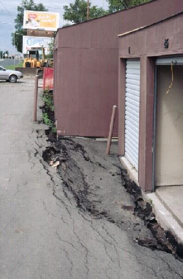
| Shortly after construction of this storage facility in West Fargo, students in an introductory geology course accurately predicted its imminent failure. The facility was constructed directly on top of a cutbank on the Sheyenne River. (1985).
(Click on image for enlargement).
|
This web site provides a geologist's perspective on land use versus slope instability in areas adjacent to the Red River of the North and its tributaries The following points will be emphasized:
- mass wasting is a natural process associated with the Red River and its tributaries.
- regions prone to slope failure are predictable, even given only a simple knowledge of the associated geology.
- the problems in the Red River Valley region are exacerbated by the unusual weakness of the sediments that underlie the valley.
- the actions of man can increase the rates and impacts of mass wasting.
- mitigation of mass wasting problems is difficult if not impossible, especially if development has already occurred on affected properties.
- avoiding the situation altogether is generally a far more efficient than engineering one's way out of a problem.
- damages to housing and infrastructure induced by mass wasting have already cost taxpayers millions of dollars.
- such damages would have been largely avoidable given proper planning.
 Residential development of lands bordering the Red River has been encouraged by developers and by attractive ads, such as that to the left. Understandably, the public is attracted to the natural beauty of such settings. Throughout the 1990's, intensive residential development has taken place on these lands. However, as will be emphasized, the type of property illustrated in the photo for this ad represents the most vulnerable type of geologic setting in the Red River Valley. Not only are these lands flood-prone, as was so well demonstrated in Spring, 1997, but they are highly susceptible to mass wasting. Residential development of lands bordering the Red River has been encouraged by developers and by attractive ads, such as that to the left. Understandably, the public is attracted to the natural beauty of such settings. Throughout the 1990's, intensive residential development has taken place on these lands. However, as will be emphasized, the type of property illustrated in the photo for this ad represents the most vulnerable type of geologic setting in the Red River Valley. Not only are these lands flood-prone, as was so well demonstrated in Spring, 1997, but they are highly susceptible to mass wasting.

|
| Mass wasting in association with the Red River has plagued the Fargo-Moorhead region, since establishment of the two cities. Note the active slumping and crude attempts at bank protection on the right (Moorhead) side of this photo, taken in 1879. View is toward the northwest.
(Click on image for enlargement).
|
Many of these properties and houses bordering the river are now in danger of failing due to unstable slopes. Property owners have claimed that they are victims, to the point that taxpayers have so far footed most of the costs for property buyouts. Given the large-scale development on such areas during the 1990's, the problem promises to persist for decades.
All of this would have been avoidable with proper land-use planning. But, who is to blame?:
- The former landowner for selling such property for residential development?
- The developer for planning development in a prone region?
- The builder for constructing homes on unstable slopes?
- The planning or zoning boards, for permitting construction in vulnerable land regions?
- The real estate agent, for marketing houses without an open evaluation of the geologic settings with potential buyers?
- The homeowner for purchasing a house adjacent to a potentially-unstable slope?
- Or, the educator, for failing to educate the general public on the relatively simple and predictable processes associated with a river such as the Red?
The authors hope that this web site provides guidance for examining present land use problems in the Red River Valley --- and avoiding similar situations in the future. The Red River holds great promise as a regional resource, but in turn the river's need to adjust its channel and to process its floodwaters must be respected through planning development away from vulnerable land regions.

|
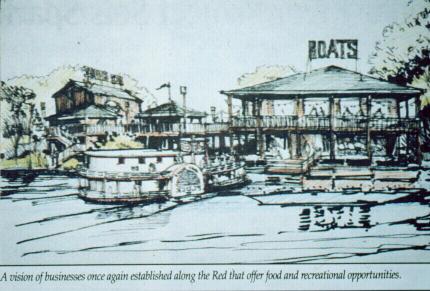
River development plans like this were proposed for Fargo in the early 1990's. Had these plans been implemented then, the setting illustrated here would have been inundated by 20 feet of water in 1997. Proper land use, whether it be to avoid flooding or slope stability problems, should avoid land surfaces prone to such geologic processes.
(Click on image for enlargement)
|

[ Return to "Slope Instability and Mass Wasting in Fargo, ND" ]
[ Return to "Geology of Fargo-Moorhead Region" ]
This web site represents the views of the authors and not necessarily those of North Dakota State University. NDSU is not responsible or liable for its contents. Copyright © 2001, Department of Geosciences, North Dakota State University.
|
 NORTH DAKOTA STATE UNIVERSITY
- FARGO, N D
NORTH DAKOTA STATE UNIVERSITY
- FARGO, N D