|
In the Fargo-Moorhead region, three types of mass wasting impact slopes bordering the Red River and its tributaries. Two of these, creep and earthflow, generally induce low levels of property damage. Slump, in contrast, can result in major and rapid slope retreat.
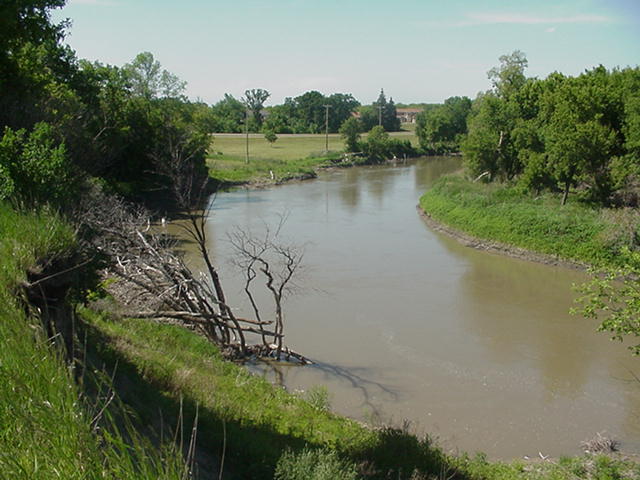
Slump is common where clay-rich materials are exposed along a steep slope. Such oversteepend slopes naturally occur on the outside of meanders along the Red River. Slump is typically identified as the downward movement of a block of earth material along some curved surface of failure. Rotation of the slump block during movement generally takes place, and trees and other features are rotated with the block:


|
Rotational slump along the Red River in north Fargo, July, 2000. Location is just northeast of the junction of Trollwood Drive and Broadway. View is to the northwest. Note the rotation of the slump block (foreground) and the association of this process with the active cutbank on the outside of the meander.
(Click on photo for enlargement)
|
Related to slumping is another process evident along some slopes bordering the Red River and its tributaries. Here, instead of the block rotating downward, it drops vertically. The occurrence of this process is frequently evidenced by a terrace-like appearance along the slopes. Unlike rotational slump, trees and other features on the displaced block continue to stand vertically.
This mass wasting process appears to be the result of the horizontal flow of weak clays toward the channel. As the clays are squeezed into the channel, the overlying ground drops vertically:

| Vertical displacement along Red River cutbank, Hendrum, MN, 1999. River is to the left of the photo scene. Trees to left had been at level of field. Note their vertical position, indicating that no rotation of the displaced block on which they are rooted has occurred. Large, still-active fissure is evident.
(Click on photo for enlargement)
|

|

|
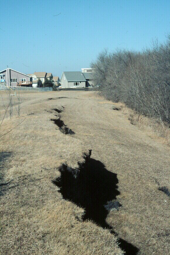
Region of N 10th Street, Fargo, March, 2000. View is to the north. Red River is to the right (east) of the photo. Two zones of fissuring have resulted in vertical displacements. The fissure in the foreground cuts along a city dike. For further information on this problem area, see Case Study #2.
(Click on photo for enlargement)
|
It should be emphasized that both of these mass wasting processes are natural phenomena, that can be expected in regions of bank erosion along the Red River --- such as those along cutbanks on the outside of river meanders.
However, man can inadvertently accelerate the process of slump development by:
- the emplacement of a load on top or along the slope, itself (for example, the dike in the photo, above)
- increasing soil moisture content, by lawn watering or installation of drain fields within prone regions.

[ Return to "Slope Instability and Mass Wasting in Fargo, ND" ]
[ Return to "Geology of Fargo-Moorhead Region" ]
This web site represents the views of the authors and not necessarily those of North Dakota State University. NDSU is not responsible or liable for its contents. Copyright © 2001, Department of Geosciences, North Dakota State University.
|
 NORTH DAKOTA STATE UNIVERSITY
- FARGO, N D
NORTH DAKOTA STATE UNIVERSITY
- FARGO, N D