 NORTH DAKOTA STATE UNIVERSITY
- FARGO, N D NORTH DAKOTA STATE UNIVERSITY
- FARGO, N D


|
|
NORTH DAKOTA STATE UNIVERSITY
- FARGO, N D
|


|

|
WORST CASE
|
 The map illustrates what are the very worst geologic settings for residential construction in the Fargo-Moorhead region. Note that each one of the houses is positioned on the outside (eroding edge, or cutbank) of the Red River, as well within the 100-year floodplain. The map illustrates what are the very worst geologic settings for residential construction in the Fargo-Moorhead region. Note that each one of the houses is positioned on the outside (eroding edge, or cutbank) of the Red River, as well within the 100-year floodplain.
|
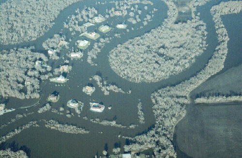 | Photo of flooded houses in
instability-prone settings, along the Red River south of Fargo, 1997. (Click on photo for enlargement) |
[ Return to "Geology of Fargo-Moorhead Region" ]
Copyright © Department of Geosciences, North Dakota State University.