|
 Home Home
Image Map
Search
References
Links
|
|
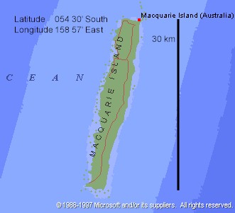
Macquarie Island
54° 62'S, 158° 97'E
- One main island; outliers Judge and Clerk Islands 16 km N, and Bishop and Clerk Islands
29 km S; of sedimentary origin with volcanic extrusions; in the Pacific Ocean.
- Area: 128 km˛.
- Highest elevation - 433 in (Mount Hamilton).
- No Glaciers.
- Sighted and first landing 1810 (by sealers).
- Permanent occupation (scientific station) from 1948 (previously sealers and scientific
personnel wintered). Sealing and penguin oil station operated 1888-1917.
- Australian State territory, part of the Municipality of Esperance, Tamania.
Macquarie Island
World Heritage Area Page
"Macquarie
Island" Australian Antarctic Program
|