1.1 History of Pedology (the study of soil development and characteristics)
Soil science has a history as diverse and rich as soil itself, and although humans have farmed for millennia, the scientific study of soils began less than 150 years ago. One of the first groundbreaking seminal events in the field took place in America in 1860, when a German immigrant by the name of Eugene Hilgard working as a geologist in Mississippi published his( 391-page book entitled “Report of the Geology and Agriculture of the State of Mississippi” . Roughly 20 years later, indepent from Hilgard’s research, a Russian geographer and geologist Vasily Dokuchaev (1846-1903; Figure 1.1a) , commonly considered the father of modern soil science, published a series of journal articles, beginning with perhaps his most famous: “Tchernozѐm (terre noire) de la Russie d’Europe” or “Chernozem (black earth) of European Russia”(St. Petersburg Society Imp. Libre ѐconom. 66p.). Before Hilgard’s and Dokuchaev’s writings, soils and bedrock were considered similar; however, both scientists independently came to the conclusion that soils were not only the product of the minerals in place due to bedrock or sediments, but they were constantly under the influence of time, soil biota/vegetation cover, climate/weather,and the soils parent location. Hans Jenny (1899-1992) (Figure 1.1b), a Swiss-born soil scientist and president of the Soil Science Society of America in 1949, embraced Dokuchaev’s work and published the book “Factors of Soil Formation: A System of Quantitative Pedology” (Jenny, 1941). This quickly became the basis of soil genesis research and interpretation in the United States and most of the world. Today’s understanding of the factors of soil formation builds directly on the factors he first proposed. The five soil-forming factors recognized today are:: parent material, topography, organisms, climate, time. The rest of this chapter discussing the soils of North Dakota is based heavily on these five factors.

1.2 The Five Soil-Forming Factors
1.2.1 Parent Materials
1.2.1.1 A brief geology of North Dakota
North Dakota’s geologic history is truly amazing. Evidence of this can be found in g as shown by drill cores taken from across the state spanning Precambrian (2.5 billion to 570 million years ago) to Lake Agassiz formations less than 10,000 years in age.
North Dakota geology in relation to its soils is a product of the sedimentary rocks produced from their position within a shallow sea millions of years ago and the much more recent legacy of glaciation over much of the state. During the past 500 million years , the area we now call North Dakota was covered by warm, shallow seas. Mean annual temperatures have ranged from 81 F℉ 60 million years ago to 68 F℉ 20 million years ago to 40 ℉F today. Erosion is a natural process, and during this long span of time, thousands of feet of sediments from surrounding dry land were displaced by water and wind erosion and deposited into this shallow sea. With time, the sea sediments grew in thickness, and their weight resulted in shale rock formation with properties related to the chemical environment in which they formed. This shale is now important not only for the chemistry it imparts to the soil above it but also to the oil and gas industry for the petroleum embedded in its layers.
North Dakota’s soil can be broadly classified into two groups based on geologic parent material, with the soils of southwestern North Dakota distinct from all others found elsewhere in the state. The soils of southwestern North Dakota are either residual in nature, having been formed on bedrock or rock-like paralithic sediments, or they formed from materials derived from these sedimentary rock formations over a millennia of landscape transformation. The other remaining areas of North Dakota inherited transported parent materials due to much more recent glacial activity during the Pleistocene epoch (2.58 million to 11,700 years ago). These glacial sediments resulted from many geomorphic processes, including movement by ice, wind and water. Consequently, each glacial landform reveals the method by which the sediments, whose sizes range from small clay particles to giant boulders, were transported and deposited. When examining the parent materials from which the soils in the south and southwestern part of north dakota have been derived, two geologic episodes, the Cretaceous and the Paleogene (Tertiary) and their resulting sediments played a primary role in the formation of the soils across the state,, as well as the young glacial process of the Pleistocene epoch.
1.2.1.1.1 Cretaceous: Western Interior Seaway
The oldest of these occurred during Cretaceous times, about 135 million to 67 million years ago. During this period, a huge lowland stretching from Texas to northern Alaska became what is called the Western Interior Cretaceous Sea. Upland areas as far east as Quebec, CA supplied sediments to this sea. Sediments translocated from the, then, emerging Rocky Mountains in the west provided additional sediments accompanied with windblown volcanic ash from the large belt of volcanoes in the Pacific Northwest. All of this resulted in a tremendously thick sequence of sedimentary shale including marine shales, and organic-rich Black shales.. This inland sea reached its greatest extent during the middle Cretaceous period, about 100 million years ago. Sediments deposited during this period resulted in shale rock layers ranging from about 500 feet thick in northeastern North Dakota to almost 4,000 feet thick in southwestern North Dakota. This shale rock layer is called the Pierre Formation, and it is the most geographically extensive shale unit in North Dakota. Shale units affect soil properties in several ways—either as surface bedrock that forms the parent material from which the soil series like Dilts, Lisam, and Cabbart in southwestern North Dakota were derived, or as shallow bedrock broken up by glaciers, contributing to the parent material in soils like Inkster, Binford, Brantford, Rolette, Walsh, and Olga.The Cretaceous shales also have had an influence on surficial groundwater chemistry and so are also causal factors in the development of saline and sodic soils all across North Dakota.
1.2.1.1.2 Paleogene (Tertiary) Continental Deposits and Lignite.
Most of the rock formations at the surface in southwestern North Dakota are Tertiary in age, dating back about 67 million to 2 million years. While the earliest Tertiary-age rocks —such as the Hells Creek and Cannonball formations—were of marine origin, the majority of the tertiary record is characterized by continental deposits. Sediments were sourced primarily from the Rocky Mountain uplift in Wyoming and Montana and transported eastward by meandering rivers. These rivers deposited sand, silt, and clay, and created vast swampy areas where organic materials accumulated. Over time, these organic-rich layers were buried by additional sediments and lithified into lignite (turned into rock).The Bullion Creek and Sentinel Butte formations contain most of North Dakota’s economic lignite deposits. Tertiary-age sediment formations in western North Dakota vary widely in composition, ranging from fine clays to coarse sands. Due to the region’s varied topography, multiple sediment types can often be encountered within relatively short distances during soil investigations.The major formations of the earliest Tertiary period, the Paleocene, cover the vast majority of western North Dakota. These include the Ludlow, Cannonball, Slope, Bullion Creek and Sentinel Butte formations. Two smaller areas of later Cretaceous sediments known as the Cannonball River and Beaver Creek formations, are exposed in western Slope and Bowman counties and at lower elevations near major drainages in Sioux and Emmons counties. North Dakota’s oldest landscapes and oldest soils typify southwestern North Dakota, which the locals refer to as the “west river” country. This is not to say that the oldest rocks exposed at the surface are in southwestern North Dakota but that this specific physiographic province has been eroding for the longest period.
1.2.1.1.3 Quaternary (Pleistocene): Glaciation and Lake Agassiz
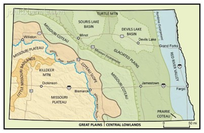
The soils of northern, central and eastern North Dakota primarily developed from glacial processes over the e past two million years North Dakota experienced six to seven glaciations during the Pleistocene, the last (Wisconsin) retreating around 11,000 years ago. These more recent events, according to the geologic time scale, resulted in a series of glaciers that invaded North Dakota, bringing in sediments and rocks from the Canadian Shield, a vast terrain of igneous and metamorphic (i.e., crystalline) rock. Some of these Shield lithologies are the oldest rocks on Earth, dating back 4.3 billion years. The glaciers also transported large amounts of limestone and dolomite from Canada into North Dakota, depositing sediments rich in finely divided calcareous or carbonate minerals. These rocks form an important source of calcium and magnesium for soils of the glacial till plain. The extent of the most recent Wisconsin age glaciation is approximately the present-day location of the Missouri River. A previous glaciation, the Napoleon Advance, pushed as far south as Dickinson and into South Dakota , but nearly all glacial material it left behind has now been eroded away. The edges of the Couteau regions are boundaries where there was temporary stability of the glaciers first 18,000 years ago (eastern boundary of the Couteau Slope) and then 10,000 years ago (eastern boundary of the Missouri Couteau). The remaining retreat of ice due to melting occurred over the next several thousand years. The major soil parent material regions (Figure 1.3) are the result of differential depth to shale due to tectonic conditions from the Rocky Mountains and the thickness of the Tertiary sediments covering the shale bedrock. The sodium, free lime and soluble salts encountered in many North Dakota soils have their origin in the Cretaceous marine shales described previously.
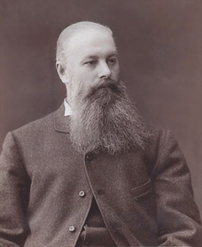
For further discussion on the soil geology of North Dakota I recommend the two books written by John P. Bluemle (Figure 1.2), former field geologist and subsequently director of the North Dakota Geological Survey, “The Face of North Dakota” (Bluemle, 1991) and “North Dakota’s Geologic Legacy” (Bluemle, 2016). Both are excellent resources for deeper understanding. This “North Dakota Soil and Fertilizer Resource” only touches on major geological features and processes affecting large areas of the state.

1.2.1.2 General soil regions of North Dakota based on parent material
Figure 1.5. General soil map of North Dakota. Omodt, 1961, NDSU Agricultural Experiment Station, Fargo, ND. Light green – loam soils of the till plain. Dark green, clay soils in the Red River Valley. Pink, dark brown soils of western plains with associated sodium soils. Brown/hashed, hilly land. Purple, very limey soils of the Red River Valley and till plains. Dark brown, badlands. White dotted, sandy.
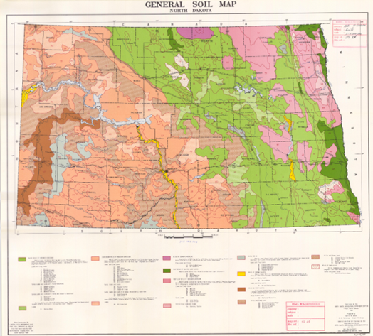
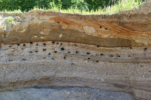
The Missouri Plateau consists of ancient sediments and sedimentary rock 65 million to 90 million years old, with soils derived from siltstone and sandstones. Within the boundaries of any given farm field in north dakota, the soils may have derived from one parent material or multiple parent materials, even within the same given field. A field may contain areas where the soil has been derived from sandstone, and at a different elevation you may also find soil derived from siltstones. When there is a juncture of these two parent materials on a slope, there is often a saline seep due to the mounding of groundwater at the plane of textural differences. The diversity of textures within the fields of western North Dakota are not nearly as great as those in the glacial till plain to the north and east. The Couteau Slope, Missouri Coteau, Glaciated Plains, Souris and Devils Lake Basins, and the Prairie Coteau all consist of glacial till interspersed with local areas of outwash. Fields within the glacial till plains have layered features because the ice that held the original sediments trapped within the glacier did not melt at the same rates during the melting process. One can imagine that a glacier with a depth ranging from hundreds of feet to thousands of feet would take a very long time to melt. When water flowed rapidly from the glacier, it transported all types of sediment, including rocks. As the flow slowed – thoughstill relatively swiftly – sands were deposited. As the velocity further decreased, silt-size particles settled out,, and finally in nearly stagnant conditions, clays were deposited. It is not unusual to find layers of sandy loam overlaying clays or silts throughout the glacial till plain. The layering of these different textures within glacial till soils leads to drainage problems within fields (Figure 1.5). When water moves downward, it must attain 100% saturation at a textural discontinuity, whether transitioning from a sandier texture to more clayey layer, or vice versa—before it can continueinto the next layer.
The Red River Valley stretching througheastern North Dakota into Minnesota, and continuing north into Manitoba as far as Lake Winnipeg, is the remnant of glacial Lake Agassiz. Clay content within the Red River Valley tends to grade from fine sandy loam and silt loams, at the western edges, to silty clay loams and clays the closer the soils are to the Red River of the North. The Red River Valley extends west out from the Red River of the North ranging from about 20 miles in the south to about 30 miles in the north. Beginning about halfway from the river to the glacial till plain is a series of beach ridge features. These features are usually subtle in height; many just a few feet higher than the dominant elevations in the area. The beach ridges can be very sandy, and highly erodible. The sands are commonly quartz based, and most have lost their topsoil towind and water erosion decades prior after first being plowed. In the area between beaches, called the interbeach area, there are often layers of different textural classes of soil, from sands to clays, with multiple contrasting soils of different properties within them. Also, the beach ridges tend to disrupt drainage patterns and contribute seep water to the water table between the ridges. Thiscan result in saltier conditions than generally experienced outside the interbeach areas. Another interesting feature of the Red River Valley is the sandy component referred to as the Sheyenne Delta region. This extends from Lisbon, east through Colfax, interrupting the nearly continuous stretch of high clay soils in the Red River Valley region. The Sheyenne Delta was formed by the sudden failure of a massive ice dam that once held back the huge glacial Lake Lanona north of Valley City. When the dam burst at the lake’s outlet it carved out what is now know as the Little Yellowstone Valley, following the landscape south from Valley City to Fort Ransom. . At Fort Ransom, the flood water turned east, redirected by some higher land forms. As it flowed east, the velocity of the water slowed, spreading north and south, and depositing thick sandy to loamy sediments. The Sheyenne Delta generally has a higher water table and is comprised of mostly sandy loam textured soils, with greater illitic clay composition than the sediments outside its boundaries. this increased illitic content is probably because of the illitic nature of the shale the water gouged into as it burst through the dam and carried away these valley sediments. Certain areas of the Sheyenne Delta, beginning at McLeod, were particularly devastated during the dust storms of the 1930s. Thousands of acres that were previously farmed, were abandoned due to the soil destruction by wind. This area was taken over by the U.S. government and is now the Sheyenne National Grassland. The Little Yellowstone River is so named, because ofr the yellow color of its exposed sediments, which are similar to the yellow rock formations seen along the Yellowstone River in Montana and Wyoming. Other than the color, there is little that reminds one of the actual Yellowstone River Valley.
1.2.2 Topography and Soils
The position of the landscape, or topography, is important for soil development due to the movement of water over and down through the soil. As Figure 1.6 illustrates, rainfall and snow melt that occur on top of a convex surface tend to move over the soil to a lower elevation within the landscape. Depressional areas collect and retain more than just the water that directly falls onto them. They also collect the runoff water from the higher landscape positions. Therefore, depressional areas retain more water than areas of higher elevations within the topography . Water availability influences vegetation growth and microbial activity. Areas that experience more drought tend to have less developed surface horizons, whereas those with adequate but not excessive water tend to have thicker, darker surface horizons.

1.2.3 Vegetation and Microorganisms
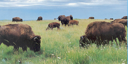
The type of vegetation native to a particular soil greatly influences that soil that develops underneath as well as the macro-microorganism communities found in that soil. In North Dakota, frequent prairie fires have kept the land in prairie grasses and associated forbs (broadleaf plants of varying genera) for at least 10,000 years. In addition, the grasslands were grazed by a variety of creatures, including huge herds of bison (Bison bison) (Figure 1.7). Grazing was important to the development of the prairie, because the grazing of perennial grasses results in the plants growing a deeper and stronger root system. The hoof activity of thousands of animals in a herd also helped to incorporate manure/urine, reducing nitrogen loss from the system. At the time of plowing, evidenced from soil survey bulletins published in the early 1900’s, dark brown/black topsoil was present across the state with at least 6% organic matter, ranging from two feet in thickness in western North Dakota counties upwards to over three feet of thickness in eastern counties.
1.2.4 Climate and Soil Development
Rainfall in North Dakota is greater in the east and much less in the west. Average annual precipitation in western North Dakota is only about 12-14 inches per year, while in eastern North Dakota it is more around 22-24 inches per year. Mean annual temperature is 37o F in the north and 43o F in the south. The growing season (days with low likelihood of frost) ranges from 140 days in the south to 128 days in the north. The cooler temperatures and long, cold frozen winters, means that microorganisms have less time to decompose plant residues, resulting in greater retention and conversion of organic carbon into organic matter.Carbon dioxide also dissolves more in colder water than warm water, which may be a reason why the northern Red River Valley is dominated by higher carbonate soils, while those in the south have less carbonates and a greater tendency to be acidic.
1.2.5 Time and North Dakota Soil Development
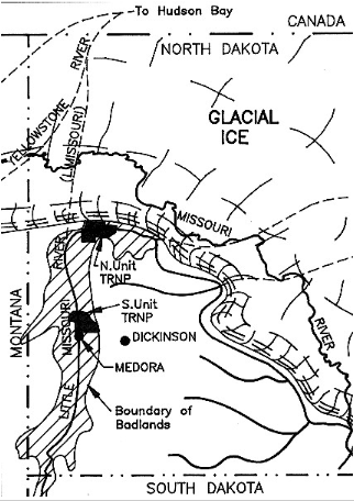
Sediments that constitute the parent material of most North Dakota soils are mainly derived from glacial materials or residual sediments from exposed rocks. Figure 1.8 illustrates the extent of the last glacial advance through North Dakota. The sediments from these glaciers range from 10,000 to 15,000 years of age. The sediments from rocks forming residuum for southwestern soils range from 65 million to 100 million years in age. The rocks are mostly sandstones and silt stones. As a result of erosion events in the distant past within a given field you might see a transition from one rock sediment type to another
1.3 References
- Baker Jr, C. H. (1967). New observations on the Sheyenne delta of glacial Lake Agassiz. US Geological Survey Professional Paper, B62-B68.
- Bluemle, J.P. (2016). North Dakota’s Geologic Legacy. North Dakota State University Press.
- Bluemle, J.P. (1991). The face of North Dakota (Educational series/North Dakota Geological Survey). North Dakota Geological Survey.
- Brophy, J.A., and J.P. Bluemle. (1983). The Sheyenne River: Its geological history and effects on Lake Agassiz. In J. T. Teller & L. Clayton (Eds.), Glacial Lake Agassiz (pp. 173-186). Geological Association of Canada.
- Dokuchaev, V.V. 1879. Tchernozѐm (terre noire) de La Russie d’Europe [Chernozem (black earth) of European Russia]. St. Petersburg Society Imp. Librѐ. 66.
- Hilgard, E. W. (1860). Report on the Geology and Agriculture of the State of Mississippi. E. Barksdale, state printer.
- Hopkins, D. G., & Franzen, D. W. (2003). Argillic horizons in stratified drift: Luverne end moraine, eastern North Dakota. Soil Science Society of America Journal, 67(6), 1790-1796. https://doi.org/10.2136/sssaj2003.1790
- Jenny, H. (1941). Factors of Soil Formation: A System of Quantitative Pedology. Dover Publications.
- Jenny H. (1961). E.W. Hilgard and the birth of modern soil science. Collana Della Revista Agrochimica.
- Karpiński, B., & Szkodo, M. (2015). Clay minerals–mineralogy and phenomenon of clay swelling in oil & gas industry. Advances in Materials Science, 15(1), 37-55.Karpinski, B. and M. Szkodo. 2015. Clay minerals:Mineralogy and phenomenon of clay swelling in oil and gas industry. Advances in Materials Science 15:37-55.
- North Dakota: People living on the land. (2014, October). State Historical Society of North Dakota. https://www.ndstudies.gov/gr8/content/unit-ii-time-transformation-1201-1860/lesson-1-changing-landscapes/topic-4-fur-bearing-animals/section-3-bison
- Omodt, H.W., D.D. Patterson, & O.P. Olson. (1961). General soil map of North Dakota. North Dakota Agricultural Experiment Station.
- Ruhe, R.V. (1969). Quaternary Landscapes in Iowa. Iowa State University Press.