A soil type is the scientific standard for a soil with specific properties relating to depth, colors, and mineralogy of its horizons; size of particles that make up the soil; its relative age in terms of weathering (not years); the natural vegetation in which it formed; its placement on the landscape; and the source of its parent material. A soil series consists of all soil types that form a continuum within the same soil type family. A soil map unit delineates a soil series, not soil types.
3.1 Color as a Tool for Soil Classification
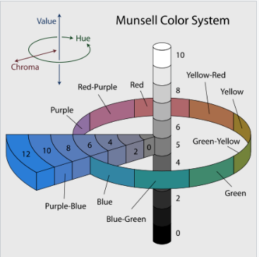
Color designation is part of a typical soil series description. The Munsell Soil Color Chart is the main tool to designate soil color for moist or dry soils, and is available from several publishers (Figure 3.1). Albert H. Munsell first developed the Munsell system in 1905. He followed this initial release with colorimetric testing of the system in laboratories, and correlation with soil scientists in the field, including T.D. Rice and K. Kelly. Munsell then adapted his color charts to soils, with a new set of color names. This new adaptation became known as the Munsell Soil Color Chart and was adopted by the American Soil Survey in 1949. The Munsell Soil Color Chart, based on the Munsell color system, defines color by breaking it into three components or attributes: hue, value, and chroma.
Hue refers to the dominant spectral color, i,e, red or yellow (common hues for soil descriptions include 10YR, 7.5YR, 5YR, and 2.5Y).
Value indicates the light or darkness of the color scaled from 0 (black) to 10 (white).
Chroma measures how weak or strong the color is. It starts at 0 (neutral gray) and assigns lower chroma values to more pastel or washed out color and higher values to more vivid or vibrant colors; there is no upper limit to chroma.
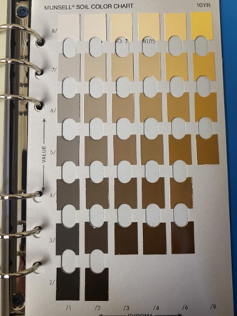
Each page of the Munsell Soil Color Chart is a different hue, and contains a grid of color chips organized by value (vertically) and chroma (horizontally). To use the Munsell soil color chart (Figure 3.2) a moist soil sample is broken up and a hue page is placed over top of the soil sample. There are holes in the pages of the chart, allowing the user to view and compare the soil sample color to the colored chips. The user starts by determining the most likely hue page then narrows it down to the chip that most closely matches the soil’s color. Once a match is found, the color of the soil is recorded using the Munsell notation.
3.2 Terms Used to Describe a Soil Series
The following acronyms, are utilized to describe levels of soil depth in the soil type descriptions that follow:
A (A Horizon): The topsoil layer, rich in organic matter and minerals. Its Dark color is due to high levels of organic material (humus) content. Ap (Plowed A horizon): The surface, or plow layer. A mixture of plant residue, organic material, and mineral soil.
B Horizon: The weather subsoil BW1: The upper, less weathered/illuviated section
BW2 (lower, with more distinct signs of weathering and illuviation).
Bk (Calcareous Horizon): A calcareous (lime-rich) B horizon, with a whiter color due to the deposited calcium carbonate.
C (C Horizon or Parent Material) Unweathered parent material or bedrock Cg1, Cg2 (Weathered Parent Material or Bedrock): Partially weathered parent material of the soil profile.
Cr (Bedrock or Unconsolidated Rock): Bedrock (solid rock) beneath the soil horizons.
Bckg (Background): Mix of calcareous poorly drained soils and weathered parent material, or bedrock deep in the profile.
3.3 Soil Type Descriptions for Selected North Dakota Soils
3.3.1 Fargo clay/silty clays
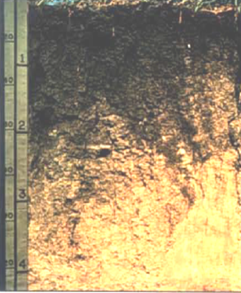
Fargo clays and Fargo silty clays are soils of the central Red River Valley, consisting of deep, poorly drained, slowly permeable soils on glacial lake plains. The soils are formed in fine textured lacustrine sediments on slopes ranging from 0% to 3% (USDA, Cass County Soil Survey, 1985) Cass County Soil Survey, N.D. Prochnow et al., US Gov. Printing Office, 1985, Washington, D.C.). Fargo clays are also found in eastern North Dakota in smaller lake bed (lacustrine) settings. Examples may be found near Havana, ND, in the southeast and near Bottineau in north-central North Dakota.
Ap 0-7 inches: black (10YR 2/1† when moist) silty clay, very dark gray (10YR 3/1 when dry); moderate subangular blocky structure parting to weak fine subangular blocky; very hard, friable, sticky and plastic‡; few fine and many very fine roots; common very fine pores; neutral pH; abrupt§, smooth boundary.
A 7-10 inches: black silty clay moist, dark gray when dry; weak medium prismatic structure parting to weak subangular blocky; very hard, friable, slightly sticky and plastic‡; few fine and many very fine roots; few fine pores; neutral pH; gradual smooth boundary.
Bw1 10-16 inches: very dark gray silty clay when moist, dark gray when dry; moderate medium prismatic structure parting to weak subangular blocky; very hard, firm, sticky and plastic; few fine and many very fine roots; few small pores; faces of peds have shiny, waxy sheen when moist; tongues of A horizon material throughout; slight effervescence in lower part when acid applied; neutral pH; gradual wavy boundary.
Bw2 16-22 inches: silty clay; very dark gray when moist, gray when dry; weak medium prismatic structure parting to weak fine angular blocky; very hard, friable, sticky and plastic‡ ; common very fine roots; few fine pores; faces of peds have shiny waxy sheen when moist; tongues of A horizon throughout; strong effervescence when acid applied; mildly alkaline; gradual wavy boundary.
Bckg 22-30 inches: silty clay; dark grayish brown when moist, grayish brown when dry; weak fine prismatic structure parting to weak medium subangular blocky; very hard, firm, sticky and plastic‡ ; few very fine roots; tongues of A horizon material; lime disseminated throughout; strong effervescence when acid applied; mildly alkaline; gradual wavy boundary.
Cg1 30-45 inches: silty clay; olive gray when moist or dry; weak prismatic structure parting to weak to medium subangular blocky; very hard, firm, sticky and plastic‡; few very fine roots; strong effervescence when acid applied; mildly alkaline; gradual wavy boundary.
Cg2 45-60 inches: silty clay; olive gray when moist or dry; common medium prominent dark brown mottles; massive structure; very hard, firm, sticky and plastic‡; few medium masses of segregated lime; strong effervescence when acid applied; moderately alkaline.
† Color designation from Munsell Soil Color Charts, 1994 revised edition. Macbeth Division of Kollmorgen Instruments Corporation, New Windsor, NY.
‡ Handling state of soil from dry to moist.
§ Abrupt boundary is due to tillage depth, and it is not the natural state for the soil series.
3.3.2 Barnes Loam
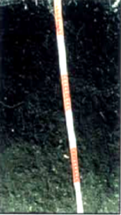
Fine-loamy, mixed, superactive, frigid Calcic Hapludolls). Barnes is a soil of central North Dakota derived from glacial till on slopes from 0% to 25%. It is very deep and well drained with moderately slow permeability.
Ap 0-7 inches: loam; black when moist (10YR 2/1†), dark gray when dry (10YR 4/1); weak medium subangular blocky structure parting to moderate medium granular; slightly hard and friable, slightly sticky and slightly plastic‡; common or many very fine and fine roots; about 5% gravel; neutral pH; abrupt boundary due to tillage depth§.
Bw 7-12 inches: loam; dark brown when moist, brown when dry; moderate medium prismatic structure parting to moderate medium subangular blocky; slightly hard and friable, slightly sticky and slightly plastic‡; common or many very fine and fine roots; about 5% gravel; neutral pH; clear, wavy boundary.
Bk 12-29 inches: loam; grayish brown when moist, light gray when dry; moderate medium subangular blocky structure; slightly hard and friable, slightly sticky and slightly plastic‡; common very fine and fine roots; about 5% gravel; many fine and medium irregularly shaped soft masses of lime; violent effervescence when acid applied; moderately alkaline; gradual wavy boundary.
C 29-60 inches: loam; dark grayish when moist, light brownish gray when dry; few fine prominent red mottles; massive; slightly hard and friable, slightly sticky and slightly plastic‡; about 5% gravel; strong effervescence when acid applied; moderately alkaline.
† Color designation from Munsell Soil Color Charts, 1994 revised edition. Macbeth Division of Kollmorgen Instruments Corporation, New Windsor, NY.
‡ Handling state of soil from dry to moist.
§ Abrupt boundary is due to tillage depth, and it is not the natural state for the soil series.
3.3.3 Vebar fine sandy loam (Figure 3.5)
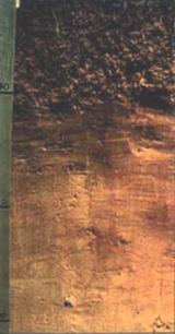
Coarse loamy, mixed, superactive, frigid Typic Haplustolls). Consists of moderately deep, well drained, moderately rapidly permeable soils on uplands on material weathered from soft sandstone bedrock on slopes 1%-20%. (U.S. Department of Agriculture, Soil Conservation Service, 1990)
Ap 0-6 inches: fine sandy loam; dark brown when moist (10YR 3/3†), brown when dry (10YR 4/3); moderate fine granular structure; slightly hard, very friable, slightly sticky and slightly plastic‡; many very fine and few fine roots; neutral pH; abrupt smooth boundary§.
Bw 6-20 inches: fine sandy loam; brown when moist, pale brown when dry; weak coarse prismatic structure parting to weak medium subangular blocky; slightly hard, very friable, nonsticky and nonplastic‡; many very fine roots; mildly alkaline; clear, smooth boundary.
Bk 20-32 inches: fine sandy loam; dark grayish brown when moist, light brownish gray when dry; weak very coarse prismatic structure parting to weak medium subangular blocky; slightly hard when dry; fine roots, common medium soft masses of lime; strong effervescence when acid applied; moderately alkaline; clear, irregular boundary.
Cr 32-60 inches: soft sandstone, light brownish gray when moist, light gray when dry; few very fine roots in weathered zones; common fine soft masses of lime in fractures; slightly effervescent; moderately alkaline.
† Color designation from Munsell Soil Color Charts, 1994 revised edition. Macbeth Division of Kollmorgen Instruments Corporation, New Windsor, NY.
‡Handling state of soil from dry to moist.
§ Abrupt boundary is due to tillage depth, and it is not the natural state for the soil series.
3.4 References for Soil Series and Soil Types
- Munsell, 1905; A.H. Munsell A Color Notation. Boston: G.H. Ellis Co.; Cleland, T.M. 1921. A practical description of the Munsell color system, and suggesting possible uses of the system. Munsell Color Company, Boston, MA.)
- Munsell Color Company, Inc. (1994). Munsell soil color charts (Revised ed.). Macbeth Division, Kollmorgen Instruments.
- U.S. Department of Agriculture, Soil Conservation Service. (1990). Hettinger County soil survey. U.S. Government Printing Office.
- U.S. Department of Agriculture, Soil Conservation Service. (1985). Cass County soil survey. U.S. Government Printing Office.
- Wikipedia contributors. (n.d.). Munsell color system [Image]. Wikipedia. https://en.wikipedia.org/wiki/Munsell_color_system#/media/File:Munsell-system.svg