 NORTH DAKOTA STATE UNIVERSITY
- FARGO, N D NORTH DAKOTA STATE UNIVERSITY
- FARGO, N D


www.ndsu.edu/fargo_geology
|

|
GEOLOGY OF THE
NORTH DAKOTA - MINNESOTA
Provided in public service by the:
|
We invite you to learn more about the geology of the Fargo region through the resources provided on this and on our related pages.
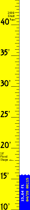 CURRENT
LEVEL:
RED RIVER
AT FARGO.
Provisional
data from
automated
station. Elev.
datum 861.80'.
The Red River Valley of North Dakota and Minnesota is a region devoid of mountains and bedrock exposures. Nonetheless, in its own way, the Valley forms a fascinating landscape. The geology can be subtle in appearance, yet startling in its impact. It profoundly affects residents of this region in many ways.
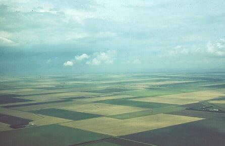
Lake Agassiz Plain
at Fargo
(Click image to enlarge).
Please e-mail us your comments and suggestions.
The automated water level is courtesy of Nem Schlecht.
Copyright © 2013, Donald P. Schwert, North Dakota State University. Except where
otherwise noted, the views expressed on these pages are those
of the author, and not NDSU.