NORTH DAKOTA STATE UNIVERSITY
- FARGO, N D NORTH DAKOTA STATE UNIVERSITY
- FARGO, N D


|
|
NORTH DAKOTA STATE UNIVERSITY
- FARGO, N D
|


|

|
CASE STUDY #4:
|
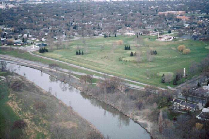
Elm Street at El Zagal Golf Course in north Fargo remains one of the city's most problematic locations of land instability. The street, itself, is located just above the outside edge of a Red River meander. Unlike the previous three case histories, a cutbank is not present here, for the region of the golf course itself is low and represents a meander scar: an abandoned segment of the old river's course. Nevertheless, erosional processes occur on the outside of this meander, as the river shifts this meander loop westward toward Elm Street.
The lowlands here are among the first in the city to flood, with the land east of Elm Street flooding at a stage of 17' and the street flooding at a stage of 19'.
El Zagal Golf Course is a 9-hole golf course operated by the Fargo Park District. In 1979, following a major flood on the Red, the District constructed a large, high dike to protect the golf course from flooding and reduce future damage to turf induced by flooding.

While perhaps resolving the problem of golf course flooding, the dike has served to accelerate damage to the lands just east of it, including Elm Street. The weight of this massive dike squeezes the weak, underlying clays, forcing clay flow toward the river. This flow induces rifting of the land surface, causing severe damage to Elm Street and adjacent bike paths. As the dike squeezes downward, a major sag has developed in its central region.
That it is inevitable that Elm Street become a dynamic and problematic area is apparent by the associated geology. However, that the dike is accelerating land instability is likewise clear. This raises the issue of the overall value of the dike. It protects only a small golf course and eliminates another portion of the natural floodplain from receiving flood waters of the Red River. This dike, and others that the Park District has constructed, can actually serve to increase the degree of flood damages upstream. Such dikes constrict the floodway and remove floodable parklands from serving as temporary basins for the storage of floodwaters. Parks are an excellent use of lands in flood-prone regions. But preventing parks from serving the dual purpose of being recreational lands and basins for the temporary storage of flood waters violates the basic principles of sound floodplain management.
The golfers at El Zagal continue to enjoy their flood-free turf, protected by an ever-sagging dike. The taxpayer, however, is left to foot the expenses of constant repair to Elm Street --- damages induced, in part, by the dike, itself.
|