People involved with agriculture and hydrology know their decisions need to be data-driven. But when dealing with climate-induced changes to soil and water, the data sets are often huge and unwieldy, making them difficult to use and without the detail that is helpful for decision making.
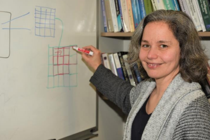
Anne Denton, ND EPSCoR-funded researcher with the Center for Regional Climate Studies and professor in the NDSU Department of Computer Science, has developed new methods for assessing the remotely sensed data (such as from satellites) and created models that can analyze the data at the level of 1 meter (about 3.3 feet) or 5 meters, rather than the traditional 30-meter grids.
“We can use the high resolution of modern imagery for extracting information that involves many pixels of those images,” Denton said, “and we can do the analysis without losing any of the resolution.”
Using the tools of big data, her research can now provide more accurate, detailed information about topographical features; for example, the slope of a hill, which will help a farmer or hydrologist better plan for handling surface water runoff. Thanks to the various imaging sources and using big data techniques, Denton can distinguish things on the ground from ground cover to detailed topography of the site.
“Doing geospatial computer analysis used to be only in the geoscience arena,” she said.
In 2011, Denton was the recipient of one of the first NSF grants in the country that focused on big data uses in agriculture: PFI: Data-driven Support for the Smart Farm.
“This research is very cutting edge, and we’re hoping to add a data science major to the computer science department here,” said Denton.
The field has grown significantly since the advent of such commonly used tools as Google Earth.
Denton has focused on what she describes as “tool development”—finding ways to use the huge image data sets in ways that provide useful and accurate information, developing structures so different sets of data can now “talk” to one another, and constructing faster tools for doing big data analysis.
“By using big data techniques,” she said, “we can use all the information we have to make better decisions, and this information is useful for agriculture, hydrology, weather and climate experts, and a host of other industries. I feel like we’ve only scratched the surface of what can be done with these new techniques we’ve been developing. I would like to get to where we can do reliable assessments of soil and plant health using the spatial imagery, because I think it would also help us address the changes in climate more effectively. We won’t run out of problems to solve in the next 50 years or so.”
In addition to research, Denton also has an enthusiasm for helping students. Recently she celebrated a first in her career.
“I had a doctoral student, Rahul Gomes, who graduated last year and got a job as a faculty member at Minot State University,” she said. “He applied for a ND EPSCoR STEM grant a few months ago as a principal investigator, and I had the honor of being named the co-PI. He got the grant.”
Helping students develop their skills so they can make an impact in the workforce in the state and across the region is important to Denton, and an ongoing focus of her work at NDSU.
This article originally appeared in the February 2020 ND EPSCoR Newsletter.
As a student-focused, land-grant, research university, we serve our citizens.