|
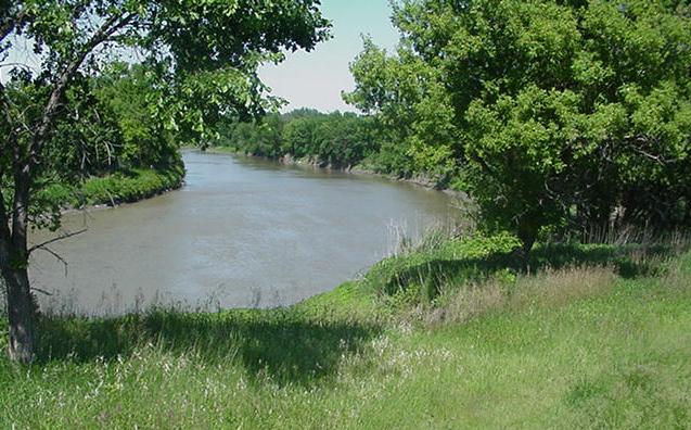
| Meander loop on Red River in north Fargo. Note the cutbank on the outside of the meander. Settings like this are lovely. But they represent precarious locations for development.
(Click on photo for enlargement).
|
The Red River Valley is underlain by a thick wedge of fine-grained sediments, whose engineering strengths are exceptionally low. Where these weak sediments are exposed "on edge" (for example, in a highway cut or along the channel of the Red River or its tributaries), they are susceptible to failure.
Rivers that flow across unconsolidated, fine-grained sediments tend to meander. Such is the case, of course, with the Red River of the North. Due to its extensive meander belt, the Red River's path northward from Wahpeton to Pembina is about twice as long as a straight-lined path.
Meanders are dynamic features. The higher velocity of river waters passing through a meander tends to be diverted toward the "outside" of the meander loop. With this diversion of velocity is a diversion of the higher stream energy: the outside edges of meander loops typically represent regions of active stream erosion.
|
|
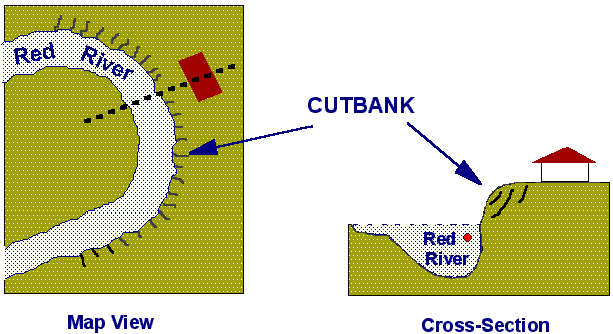
Map and cross-sectional views of a typical meander loop on the Red River. The zone of highest velocity (red dot  on cross-section) is diverted toward the outside of the meander. Thus, the outside of a meander generally represents a region of active erosion, where cliffs or cutbanks develop. While these areas may present desirable views onto the river, they are also prone to failure and mass wasting. Along such areas, the emplacement of any weight (house, dike, walls, or even the simple watering of a lawn) only tends to exacerbate the rate of slope failure. on cross-section) is diverted toward the outside of the meander. Thus, the outside of a meander generally represents a region of active erosion, where cliffs or cutbanks develop. While these areas may present desirable views onto the river, they are also prone to failure and mass wasting. Along such areas, the emplacement of any weight (house, dike, walls, or even the simple watering of a lawn) only tends to exacerbate the rate of slope failure.
|
The development of meanders is a natural operation of such rivers. After witnessing decades of futile projects involving channel straightening, most geologists and engineers appreciate that a river has a need to meander.
With the river ever cutting toward the outside edges of its meanders, the channel over time shifts in position. The erosional cliff (cutbank) retreats by erosion and mass wasting, shifting the channel in a direction toward the outside of the meander.
|

|
| The river channel shifts over time in a direction toward the outside of the meander loop. As erosion progresses, cutbank slopes become unstable under gravity and susceptible to mass wasting.
|
Many of the parklands of eastern Fargo (Mickelson Field, "Elephant" Park, Trollwood Park, El Zagal Golf Course, Lindenwood Park, etc.) are developed on abandoned meander loops of the Red River: evidence of this river's past dynamic history of an ever-shifting channel.

|
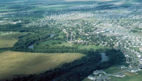
| New housing along Red River in south Fargo. Note proximity of some housing to vulnerable slopes on outsides of meanders.
(Click on photo for enlargement).
|
|
Lands bordering the outside margins of meander loops are inheritantly unstable. Yet residential development in the Fargo-Moorhead region continues on these vulnerable land surfaces.
Rates of slope retreat are difficult to predict. Aside from the rate of erosional processes induced by the river, they are also tied to:
- Soil moisture conditions (rates have increased dramatically since 1993, when the "late 1980's" drought ended).
- Water levels in the Red River (higher water levels tend to induce a positive pressure against the river bank, slowing the movement of earth materials channelward).
- The actions of man (removing stabilizing vegetation, adding load on top of the slope, introducing water on and into the affected areas, etc.)

|
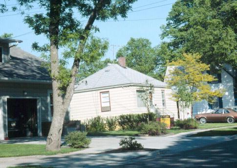
The backward tilt of this small house on N. Terrace Street in Fargo bordered on a shallow meander loop of the Red River. As the slope progressively failed, the house began to incline toward the river. The house suffered flooding in 1997 and was razed shortly thereafter.
(Click on photo for enlargement)
|
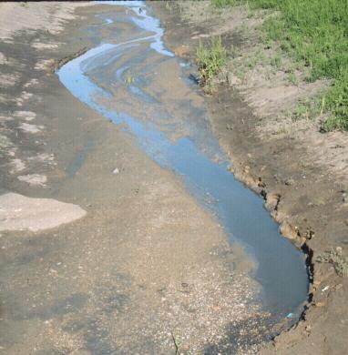
| Meandering is a natural operation of streams of all sizes flowing across fine-grained sediments. Only a couple of weeks after this (straight) county drain in north Moorhead was widened, the small stream at its base had already developed a meander pattern. Notice the cutbank development on the outside of each one of the meanders.
(Click on photo for enlargement)
|

|
The geology is simple, and the process is inevitable. The lesson should be equally simple: no residential development should occur in these prone areas. But this lesson has largely gone unheeded --- leading to expensive property losses, often at taxpayers' expense.

[ Return to "Slope Instability and Mass Wasting in Fargo, ND" ]
[ Return to "Geology of Fargo-Moorhead Region" ]
This web site represents the views of the authors and not necessarily those of North Dakota State University. NDSU is not responsible or liable for its contents. Copyright © 2001, Department of Geosciences, North Dakota State University.
|
 NORTH DAKOTA STATE UNIVERSITY
- FARGO, N D
NORTH DAKOTA STATE UNIVERSITY
- FARGO, N D