Compatibility of North Dakota Soils for Irrigation
(AE1637, Revised March 2023)This publication is intended as a first step to help current and prospective irrigators understand the principles behind the irrigability of soils in North Dakota. This publication lists all the soils in the state with relevant properties and categorizes them as irrigable, conditional or nonirrigable.
Contact your county NDSU Extension office to request a printed copy.
NDSU staff can order copies online (login required).
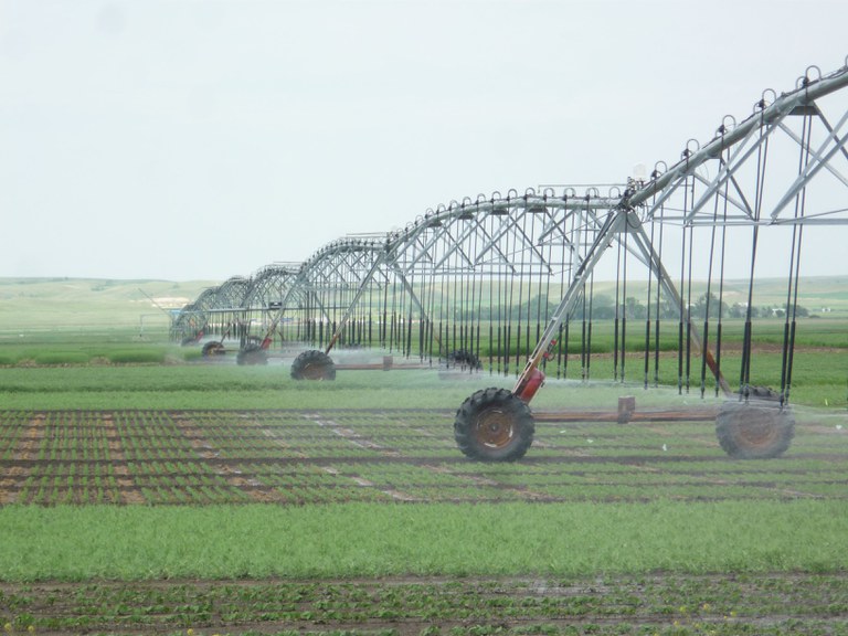
Irrigation increases the productivity of soils and the effectiveness and consistency of certain soil-applied herbicides, and provides a stable supply of farm products for food product processors. However, irrigation can degrade the quality of soil and cause crop yields to decline, even to the point of field abandonment when soil and irrigation water are not compatible.
Examples of soil degradation and land abandonment due to improper irrigation exist throughout history. When irrigation acreage expands to new areas, determining soil and water compatibility is critical for sustaining yields at high levels.
Irrigation Water Management
Irrigability Groups
In the following text,
< = less than
> = greater than
dS/m = deciSiemens per meter
EC = electrical conductivity
SAR = sodium absorption ratio
Irrigable Soils (i)
Irrigable soils generally require less management than conditional soils. Even though the soils are in an irrigable class, good irrigation management is essential. Attention to the allowable irrigation water quality is important. The use of lower-quality water than recommended can lower the productivity of the soils from salts and sodium. Different phases of each soil series may modify irrigation recommendations.
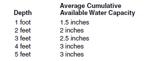
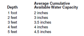
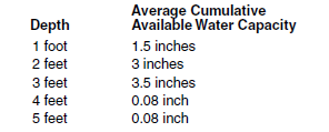
1i. Brandenburg, Coe, Kirby, Ringling, Sioux, Tinsley, Wabek, Wamduska, Wibaux
Drainage: excessively drained
Surface texture: L, SL
Substratum texture: sand and gravel
Surface intake rate for sprinkler irrigation: 0.5-0.7 inch/hour for slopes < 6 percent
Limiting permeability within 40 inches: 0.6 to 2 inches/hour in the upper part and > 6 inches/hour in the lower part
Profile characteristics: shallow/very shallow (< 20 inches) to sand, gravel and porcellanite (scoria)
Depth to lime: 0-10 inches
Surface pH: 6.6-8.4
EC (maximum within 40 inches in dS/m): 0
SAR (maximum within 40 inches): 0
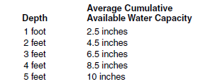
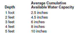
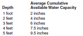
Water-holding Capacity (rounded to the nearest 0.5 inch; on-site values may vary)
Irrigation Water Quality
Maximum allowable EC < 3 dS/M; maximum allowable SAR <12
Water Management Practices
Water management on these soils is critical because of low available water capacity and nutrient leaching hazard.
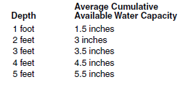
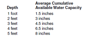
2i. Aylmer, Banks, Blanchard, Claire, Falsen, Flaming, Lohnes, Sandberg, Serden, Seroco, Valentine, Yetull, Zeona
Drainage: moderately well to excessively drained
Surface texture: CoS, S, FS, LCoS, LS, LFS, CoSL, SL, FSL
Subsoil texture: FS, S, LCoS, CoS
Surface intake rate for sprinkler irrigation: 0.5->1 inch/hour for slopes < 9 percent
Limiting permeability within 40 inches: 6-20 inches/hour
Profile characteristics: sandy and moderately coarse-textured material
Depth to lime: 10-30 inches
Surface pH: 6.1-7.3
EC (maximum within 40 inches in dS/m): 0
SAR (maximum within 40 inches): 0
Water-holding Capacity (rounded to the nearest 0.5 inch; on-site values may vary)

Irrigation Water Quality
Maximum allowable EC < 3 dS/m; maximum allowable SAR <12
Water Management Practices
Water management on these soils is critical because of low available water-holding capacity and nutrient leaching hazard.
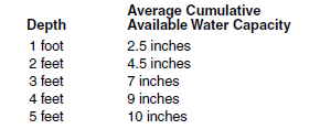
3i. Appam, Arvilla, Binford, Clontarf, Cozberg, Hanly, Hecla, Hilaire, Lihen, Maddock, Manning, Metigoshe, Osakis, Ruso, Schaller, Sverdrup, Telfer, Walum
Drainage: moderately well to somewhat excessively drained
Surface texture: FSL, SL, CoSL, LFS, LS
Subsoil and substratum texture: SL and L in the upper part and LS to sand and gravel in the lower part
Surface intake rate for sprinkler irrigation: 0.4-1.5 inches/hour for slopes < 6 percent
Limiting permeability within 40 inches: 2-20 inches/hour in the upper part and > 6 inches/hour in the lower part
Profile characteristics: moderately coarse and medium-textured material in the upper part and coarse-textured material in the lower part
Depth to lime: 10-30 inches
Surface pH: 6.1-7.8
EC (maximum within 40 inches in dS/m): 0
SAR (maximum within 40 inches): 0
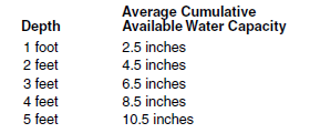
Water-holding Capacity (rounded to the nearest 0.5 inch; on-site values may vary)
Irrigation Water Quality
Maximum allowable EC < 3 dS/m; maximum allowable SAR <12
Water Management Practices
An irrigation scheduling system must be used.
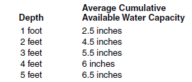
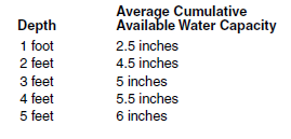
4i. Breien, Chinook, Egland, Embden, Glendive, Inkster, Mott, Parshall, Tally, Trembles, Velva
Drainage: well and moderately well drained
Surface texture: SL, FSL, L
Subsoil texture: SL, FSL, L
Surface intake rate for sprinkler irrigation: .5-1 inch/hour for slopes < 6 percent
Limiting permeability within 40 inches: 0.6-6 inches/hour
Profile characteristics: moderately coarse and medium-textured material
Depth to lime: 10-20 inches
Surface pH: 6.1-8.4
EC (maximum within 40 inches in dS/m): 0-2
SAR (maximum within 40 inches): 0
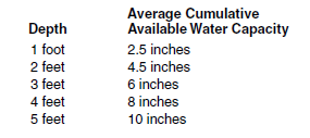
Water-holding Capacity (rounded to the nearest 0.5 inch; on-site values may vary)
Irrigation Water Quality
Maximum allowable EC < 3 dS/m; maximum allowable SAR <12
Water Management Practices
An irrigation scheduling system must be used.
5i. Baahish, Brantford, Hidatsa, Kensal, Lehr, Renshaw, Shibah, Wanagan, Warsing
Drainage: well and moderately well drained
Surface texture: SL, L
Substratum texture: 2C material is GrSL to sand and gravel
Surface intake rate for sprinkler irrigation: 0.5-0.7 inch/hour for slopes < 6 percent
Permeability within 40 inches: 0.6-2 inches/hour in the upper part and > 6 inches/hour in the lower part
Profile characteristics: moderately coarse and medium-textured material over sand and gravel that is shallow to moderately deep (< 40 inches)
Depth to lime: 10-20 inches
Surface pH: 6.1-7.8
EC (maximum within 40 inches in dS/m): 0 to 1
SAR (maximum within 40 inches): 0
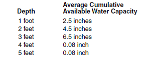
Water-holding Capacity (rounded to the nearest 0.5 inch; on-site values may vary)
Irrigation Water Quality
Maximum allowable EC < 3 dS/m; maximum allowable SAR <9
Water Management Practices
An irrigation scheduling system must be used.
6i. Bowdle, Brisbane, Bulltop, Chanta, Fordville, Littlemo, Ridgelawn, Spottswood, Stady, Vang
Drainage: moderately well and well drained
Surface texture: L, SIL, CL
Subsoil texture: L and CL in B horizons and GrL to GrS in the 2B or 2C horizons
Surface intake rate for sprinkler irrigation: 0.5-0.7 inch/hour for slopes < 6 percent
Limiting permeability within 40 inches: 0.6-2 inches/hour in the upper part and > 6 inches/hour in the lower part
Profile characteristics: moderately fine-textured material over moderately deep (20-40 inches) sand and gravel
Depth to lime: 15-30 inches
Surface pH: 6.1-7.3
EC (maximum within 40 inches in dS/m): 0-1
SAR (maximum within 40 inches): 0
Water-holding Capacity (rounded to the nearest 0.5 inch; on-site values may vary)
Irrigation Water Quality
Maximum allowable EC < 3 dS/m: maximum allowable SAR < 9
Water Management Practices
An irrigation scheduling system must be used.
7i. Arnegard, Beotia, Eckman, Emrick, Gardena, Heimdal, Kremlin, Linton, Mandan, Roseglen, Shambo, Straw, Tansem
Drainage: moderately well and well drained
Surface textures: VFSL, SIL, L
Subsoil texture: VFSL, SIL, L, SICL
Surface intake rate for sprinkler irrigation: 0.1-0.5 inch/hour for slopes < 3 percent
Limiting permeability within 40 inches: 0.2-2 inches/hour
Profile characteristics: medium and moderately fine-textured material
Depth to lime: 15-30 inches
Surface pH: 6.6-7.8
EC (maximum within 40 inches in dS/m): 0-2
SAR (maximum within 40 inches): 0
Water-holding Capacity (rounded to the nearest 0.5 inch; on-site values may vary)
Irrigation Water Quality
Maximum allowable EC < 2.25 dS/m; maximum allowable SAR < 6
Water Management Practices
An irrigation scheduling system must be used.
Conditional Soils (c)
Conditional soils can be irrigated under a high level of management. Soil conditions that contribute to conditional status are the presence of salts, poor drainage properties, the presence of subsurface layering, and the need for supplemental surface and subsurface drainage. Irrigation without high levels of management may degrade the soil quality for future generations but can be irrigated successfully if recommendations are followed. Soil phases of each soil series may modify irrigation recommendations.
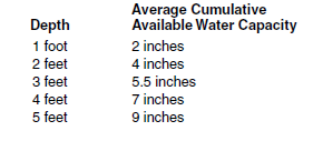
8c. Aastad, Barnes, Bowbells, Bryant, Falkirk, Farland, Farnuf, Felor, Forman, Golva, Grassna, Great Bend, Hamlet, Korell, Kranzburg, La Prairie, LaDelle, Lakoa, Lankin, Lismore, Makoti, Max, Overly, Svea, Temvik, Walsh, Williams, Wilton
Drainage: moderately well to well drained
Surface texture: L, SIL, SICL
Subsoil texture: L, CL, SICL
Surface intake rate for sprinkler irrigation: 0.1-0.7 inch/hour for slopes < 3 percent
Limiting permeability within 40 inches: 0.2-2 inches/hour
Profile characteristics: medium and moderately fine-textured material
Depth to lime: 10-20 inches
Surface pH: 6.1-7.8
EC (maximum within 40 inches in dS/m): 0-4
SAR (maximum within 40 inches): < 2
Water-holding Capacity (rounded to the nearest 0.5 inch; on-site values may vary)
Irrigation Water Quality
Maximum allowable EC < 1.5 dS/m; maximum allowable SAR < 6
Water Management Practices
These soils are conditional for irrigation due to moderate and moderately slow permeability and a potential for salinity increase in the subsoil. Salinity of the root zone should be monitored on a three- to five-year basis or more frequently if plant growth is restricted. Water, additional to that used for crop production, may be required for leaching. Leaching should be done in the fall or early spring, when crop requirements for water are low. An irrigation scheduling system must be used.
9c. Balaton, Buse, Cherry, Esmond, Fairdale, Havre, Havrelon, Korchea, Lambert, Langhei, Lonna, Machetah, Patent, Rondell, Rusklyn, Sakakawea, Sisseton, Sutley, Vida, Zahl, Zell
Drainage: moderately well and well drained
Surface texture: VFSL, FSL, SL, L, SIL, CL, SICL 2/
Subsoil texture: L, SIL, CL, SICL
Surface intake rate for sprinkler irrigation: 0.5-0.7 inch/hour for slopes < 3 percent
Limiting permeability within 40 inches: 0.6-2 inches/hour
Profile characteristics: calcareous/medium and moderately fine-textured materials
Depth to lime: 0-10 inches
Surface pH: 6.6-8.4
EC (maximum within 40 inches in dS/m): < 4
SAR (maximum within 40 inches): < 2
Water-holding Capacity (rounded to the nearest 0.5 inch; on-site values may vary)
Irrigation Water Quality
Maximum allowable EC < 1.8 dS/m; maximum allowable SAR < 6
Water Management Practices
These soils are conditional for irrigation due to moderate and moderately slow permeability and a potential for salinity increase in the subsoil. Salinity of the root zone should be monitored on a three- to five-year basis or more frequently if plant growth is restricted. Water, additional to that used for crop production, may be required for leaching. Leaching should be done in the fall or early spring, when crop requirements for water are low. An irrigation scheduling system must be used.
10c. Bearpaw, Bottineau, Croke, Ethridge, Grail, Kelvin, Mondamin, Savage, Tanna, Waukon, Zeeland
Drainage: moderately well and well drained
Surface texture: L, CL, SICL
Subsoil texture: CL, SICL, SIC, C (> 35 percent clay)
Surface intake rate for sprinkler irrigation: 0.1-0.5 inch/hour for slopes < 3 percent
Limiting permeability within 40 inches: 0.06-0.6 inch/hour
Profile characteristics: moderately fine to fine-textured material
Depth to lime: 15-40 inches
Surface pH: 6.1-7.8
EC (maximum within 40 inches in dS/m): < 4
SAR (maximum within 40 inches): < 4
Water-holding Capacity (rounded to the nearest 0.5 inch; on-site values may vary)
Irrigation Water Quality
Maximum allowable EC < 1 dS/m; maximum allowable SAR < 6
Water Management Practices
These soils are conditional for irrigation due to moderately slow and slow permeability and a potential for salinity increase in the subsoil. Salinity of the root zone should be monitored on a three- to five-year basis or more frequently if plant growth is restricted. Water, additional to that used for crop production, may be required for leaching. Leaching should be done in the fall or early spring, when crop requirements for water are low. Subsurface drainage may be required for continued irrigation. An irrigation scheduling system must be used.
11c. Aberdeen, Alkabo, Belfield, Cathay, Cresbard, Niobell
Drainage: moderately well and well drained
Surface texture: L, SIL, SICL
Subsoil texture: CL, SICL (> 35 percent clay)
Surface intake rate for sprinkler irrigation: 0.1-0.7 inch/hour for slopes < 3 percent
Limiting permeability within 40 inches: 0.06-0.2 inch/hour
Profile characteristics: moderately fine and fine-textured material that have a degraded natric horizon within 20 inches
Depth to lime: 20-30 inches
Surface pH: 5.6-7.3
EC (maximum within 40 inches in dS/m): 2-8
SAR (maximum within 40 inches): 5-15
Water-holding Capacity (rounded to the nearest 0.5 inch; on-site values may vary)
Irrigation Water Quality
Maximum allowable EC < 1.5 dS/m; maximum allowable SAR < 4
Water Management Practices
These soils are marginal for irrigation, and irrigation of extensive areas should be avoided. Continued irrigation potentially could cause restricted water intake and permanent soil damage. Salinity of the root zone should be monitored on a three- to five-year basis or more frequently if plant growth is restricted. Water, additional to that used for crop production, may be required for leaching. Leaching should be done in the fall or early spring, when crop requirements for water are low. Subsurface drainage may be required for continued irrigation.
12c. Amor, Boxwell,Chama, Edgeley, Little Horn, Marmarth, Moreau, Morton, Omio, Reeder, Regent, Searing, Sen, Watrous
Drainage: well drained
Surface texture: L, SIL, SICL
Subsoil texture: L, SIL, SICL
Surface intake rate for sprinkler irrigation: 0.1-0.5 inch/hour for slopes < 3 percent
Limiting permeability within 40 inches: 0.0-0.6 inch/hour depending on texture of soft weathered bedrock
Profile characteristics: medium and moderately fine-textured materials moderately deep (20-40 inches) to soft weathered bedrock
Depth to lime: 10-20 inches
Surface pH: 6.1-7.8
EC (maximum within 40 inches in dS/m): 2-8
SAR (maximum within 40 inches): 0-4
Water-holding Capacity (rounded to the nearest 0.5 inch; on-site values may vary)
Irrigation Water Quality
Maximum allowable EC < 1.8 dS/m; maximum allowable SAR < 6
Water Management Practices
These soils are marginal for irrigation due to moderately deep (20-40 inches) bedrock and the potential for lateral seepage. Avoid irrigating extensive areas or where stratification is evident and seeps are present. Salinity monitoring should be done on a three- to five-year basis or more frequently if plant growth is restricted. An irrigation scheduling system must be used.
13c. Beisigl, Lefor, Rhame, Tusler, Vebar
Drainage: well to somewhat excessively drained
Surface texture: LS, LFS, SL, FSL
Subsoil texture: LS, LFS, SL, FSL
Surface intake rate for sprinkler irrigation: 0.5-1.5 inches/hour for slopes < 3 percent
Limiting permeability within 40 inches: 0.0-0.6 inch/hour
Profile characteristics: coarse and moderately coarse-textured material moderately deep (20-40 inches) to soft weather beds
Depth to lime: 10-20 inchesSurface pH: 6.1-7.8
EC (maximum within 4 inches in dS/m): 0
SAR (maximum within 40 inches): 0
Water-holding Capacity (rounded to the nearest 0.5 inch; on-site values may vary)
Irrigation Water Quality
Maximum allowable EC < 1.8 dS/m; maximum allowable SAR < 6
Water Management Practices
These soils are marginal for irrigation due to moderately deep (20-40 inches) bedrock and the potential for lateral seepage. Avoid irrigating extensive areas or where stratification is evident and seeps are present. Salinity monitoring should be done on a three- to five-year basis or more frequently if plant growth is restricted. An irrigation scheduling system must be used.
14c. Dickey, Flaxton, Krem, Lanona, Livona, Swenoda, Towner, Virgelle, Yegen
Drainage: moderately well and well drained
Surface texture: LS, LFS, SL, FSL
Subsoil texture: L, CL, SICL
Surface intake rate for sprinkler irrigation: 0.5-1.5 inches/hour for slopes < 3 percent
Limiting permeability within 40 inches: 0.2-0.6 inch/hour
Profile characteristics: coarse-textured material over medium and moderately fine-textured material
Depth to lime: > 15 inches
Surface pH: 6.1-7.3
EC (maximum within 40 inches in dS/m): 0-4
SAR (maximum within 40 inches): < 2
Water-holding Capacity (rounded to the nearest 0.5 inch; on-site values may vary)
Irrigation Water Quality
Maximum allowable EC < 1.8 dS/m; maximum allowable SAR < 9
Water Management Practices
These soils are conditional for irrigation due to the subsoil’s moderately slow permeability and potential for increased salinity. Salinity in the root zone should be monitored on a three- to five-year basis or more frequently if plant growth is restricted. Water, additional to that used for crop production, may be required for leaching. Leaching should be done in the fall or early spring, when crop requirements for water are low. An irrigation scheduling system must be used.
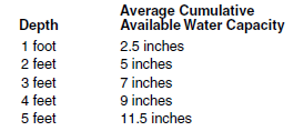
15c. Antler, Augsberg, Bearden, Bigsandy, Cashel, Colvin, Doran, Flom, Galchutt, Gilby, Hamerly, LaMoure, Lowe, McKeen, Neche, Perella, Rauville, Regan, Roliss, Styrene, Vallers, Wheatville, Winger, Wyard
Drainage: somewhat poorly and poorly drained
Surface texture: L, SIL, SICL, SIC, C
Subsoil texture: L, SIL, SICL, SIC, C
Surface intake rate for sprinkler irrigation: 0.1-0.7 inch/hour for slopes < 3 percent
Limiting permeability within 40 inches: 0.2-0.6 inch/hour
Profile characteristics: medium to fine-textured materials
Depth to lime: 0-10 inches
Surface pH: 6.6-8.4
EC (maximum within 40 inches in dS/m): < 6
SAR (maximum within 40 inches): < 3
Water-holding Capacity (rounded to the nearest 0.5 inch; on-site values may vary)
Irrigation Water Quality
Maximum allowable EC < 1.5 dS/m; maximum allowable SAR < 6
Water Management Practices
Irrigate only if adequate surface and subsurface drainage has been provided. Salinity of the root zone should be monitored on a three- to five-year basis or more frequently if plant growth is restricted. An irrigation scheduling system must be used.
16c. Divide, Marysland
Drainage: somewhat poorly and poorly drained
Surface texture: L, CL, SIL
Subsoil texture: L, CL
Surface intake rate for sprinkler irrigation: 0.1-0.5 inch/hour for slopes < 3 percent
Limiting permeability within 40 inches: 0.6-2 inches/hour in the upper part and > 6 inches/hour in the lower part
Profile characteristics: Aeric and Typic Calciaquolls, medium and moderately fine-textured material over sand and gravel
Depth to lime: 0-10 inches
Surface pH: 7.4-8.4
EC (maximum within 40 inches in dS/m): < 2
SAR (maximum within 40 inches): 0
Water-holding Capacity (rounded to the nearest 0.5 inch; on-site values may vary)
Irrigation Water Quality
Maximum allowable EC < 3 dS/m; maximum allowable SAR < 9
Water Management Practices
Irrigate only if adequate surface and subsurface drainage has been provided. Salinity of the root zone should be monitored on a three- to five-year basis or more frequently if plant growth is restricted. An irrigation scheduling system must be used.
17c. Bohnsack, Borup, Elmville, Fram, Glyndon
Drainage: somewhat poorly and poorly drained
Surface texture: FSL, SIL, L
Subsoil texture: FSL, SIL, L
Surface intake rate for sprinkler irrigation: 0.5-1 inch/hour for slopes < 3 percent
Limiting permeability within 40 inches: 0.6-2 inches/hour
Profile characteristics: Aeric and Typic Calciaquolls, moderately coarse and medium-textured material
Depth to lime: 0-10 inches
Surface pH: 7.4-8.4
EC (maximum within 40 inches in dS/m): < 6
SAR (maximum within 40 inches): 0-1
Water-holding Capacity (rounded to the nearest 0.5 inch; on-site values may vary)
Irrigation Water Quality
Maximum allowable EC < 2.25 dS/m; maximum allowable SAR < 6
Water Management Practices
Irrigate only if adequate surface and subsurface drainage has been provided. Salinity of the root zone should be monitored on a three- to five-year basis or more frequently if plant growth is restricted. An irrigation scheduling system must be used.
18c. Banks (variant), Bantry, Cormant, Fossum, Garborg, Hamar, Karlsruhe, Minnewaukan, Poppleton, Rosewood, Ulen, Venlo, Verendrye, Wyrene
Drainage: somewhat poorly and poorly drained
Surface texture: CoSL, LFS, LS, FS, S
Subsoil texture: LFS, LS, S, FS
Surface intake rate for sprinkler irrigation: 0.5-1.5 inches/hour for slopes < 3 percent
Limiting permeability within 40 inches: 2-20 inches/hour
Profile characteristics: coarse and moderately coarse-textured material
Depth to lime: 0-30 inches
Surface pH: 6.1-8.4
EC (maximum within 40 inches in dS/m): 0-2
SAR (maximum within 40 inches): 0-1
Water-holding Capacity (rounded to the nearest 0.5 inch; on-site values may vary)
Irrigation Water Quality
Maximum allowable EC < 3 dS/m; maximum allowable SAR < 12
Water Management Practices
Irrigate only if adequate surface and subsurface drainage has been provided. Salinity of the root zone should be monitored on a three- to five-year basis or more frequently if plant growth is restricted. An irrigation scheduling system must be used.
19c. Arveson, Delamere, Fossum, Galatin, Mantador, Tiffany, Tolna, Wyndmere, Wyrene
Drainage: somewhat poorly and poorly drained
Surface texture: VFSL, FSL, SL
Subsoil texture: VFSL, FSL, SL
Surface intake rate for sprinkler irrigation: 0.5-1.25 inches/hour for slopes < 3 percent
Limiting permeability within 40 inches: 2-6 inches/hour
Profile characteristics: moderately coarse and medium-textured material
Depth to lime: Calciaquolls 0-10 inches, Aquolls > 20 inches
Surface pH: 6.1-8.4
EC (maximum within 40 inches in dS/m): 0-2
SAR (maximum within 40 inches): 0-1
Water-holding Capacity (rounded to the nearest 0.5 inch; on-site values may vary)
Irrigation Water Quality
Maximum allowable EC < 3 dS/m; maximum allowable SAR < 12
Water Management Practices
Irrigate only if adequate surface and subsurface drainage has been provided. Salinity of the root zone should be monitored on a three- to five-year basis or more frequently if plant growth is restricted. An irrigation scheduling system must be used.
20c. Espelie, Grimstad, Kratka, Rockwell, Tiffany, Wyndmere
Drainage: somewhat poorly and poorly drained
Surface texture: L, FSL, SL, LFS, LS
Subsoil texture: SL, SIL, L, CL
Surface intake rate for sprinkler irrigation: 0.5-1.5 inches/hour for slopes < 3 percent
Limiting permeability within 40 inches: 0.2-2 inches/hour
Profile characteristics: coarse and moderately coarse-textured material over medium-textured material
Depth to lime: 0 -10 Inches
Surface pH: 7.4-8.4
EC (maximum within 40 inches in dS/m): < 4
SAR (maximum within 40 inches): < 2
Water-holding Capacity (rounded to the nearest 0.5 inch; on-site values may vary)
Irrigation Water Quality
Maximum allowable EC < 1.8 dS/; maximum allowable SAR < 9
Water Management Practices
Irrigate only if adequate surface and subsurface drainage has been provided. Salinity of the root zone should be monitored on a three- to five-year basis or more frequently if plant growth is restricted. An irrigation scheduling system must be used.
21c. Gwinner, Hattie, Hoffmanville, Lawther, Lohler, Magnus, Marias, Nutley, Olga, Peever, Promise, Rolette, Rolla, Scorio, Sinai, Wahpeton, Wildrose, Wolf Point
Drainage: moderately well and well drained
Surface texture: SIC, C
Subsoil texture: SIC, C
Surface intake rate for sprinkler irrigation: 0.1-0.2 inch/hour for slopes < 3 percent
Limiting permeability within 40 inches: 0.06-0.2 inch/hour
Profile characteristics: fine-textured material
Depth to lime: 0-20 inches
Surface pH: 7.3-8.4
EC (maximum within 40 inches in dS/m): 1-4
SAR (maximum within 40 inches): 0-1
Water-holding Capacity (rounded to the nearest 0.5 inch; on-site values may vary)
Irrigation Water Quality
Maximum allowable EC < 1 dS/m; maximum allowable SAR < 6
Water Management Practices
These soils are conditional for irrigation due to moderately slow and slow permeability and a potential for salinity increase in the subsoil. Salinity of the root zone should be monitored on a three- to five-year basis or more frequently if plant growth is restricted. Water, additional to that used for crop production, may be required for leaching. Leaching should be done in the fall or early spring, when crop requirements for water are low. Subsurface drainage may be required for continued irrigation. An irrigation scheduling system must be used.
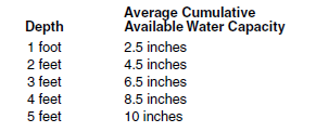
22c. Dimmick, Dovray, Enloe, Fargo, Fulda, Grano, Hegne, Lallie, Lindaas, Ludden, McDonaldsville, McKenzie, Parnell, Southam, Suomi, Thiefriver, Tonka, Viking
Drainage: poorly drained and drained phases of poorly and very poorly drained
Surface texture: L, SIL, SICL, SIC, C
Subsoil texture: SIC, C
Surface intake rate for sprinkler irrigation: 0.1-0.4 inch/hour for slopes < 3 percent
Limiting permeability within 40 inches: 0.06-0.2 inch/hour
Profile characteristics: medium to fine-textured material in the upper part and fine-textured material in lower part
Depth to lime: 0 > 40 inches
Surface pH: 6.1-8.4
EC (maximum within 40 inches in dS/m): < 4
SAR (maximum within 40 inches): 0
Water-holding Capacity (rounded to the nearest 0.5 inch; on-site values may vary)
Irrigation Water Quality
Maximum allowable EC < 1 dS/m; maximum allowable SAR < 6
Water Management Practices
These soils are conditional for irrigation due to slow permeability, wetness and a potential for salinity increase. Salinity of the root zone should be monitored on a three- to five-year basis or more frequently if plant growth is restricted. Water, additional to that used for crop production, may be required for leaching. Leaching should be done in the fall or early spring, when crop requirements for water are low. An irrigation scheduling system must be used.
References
Franzen, D. 2012, NDSU Extension publication SF1087, Managing Saline Soils in North Dakota.
U.S. Salinity Laboratory Staff. 1954. Diagnosis and improvement of saline and alkaline soils. Agricultural Handbook No. 60, U.S. Department of Agriculture, U.S. Government Printing Office, Washington D.C.
Irrigation Water Quality – Soil Compatibility Guidelines, 1987. Saskatchewan Water Corporation, Outlook, Canada.