Riparian Complex Ecological Sites of North Dakota
(R1791, Revised March 2026)The following is a pictorial guide of the valleys, streams and plant communities common in riparian complex ecological sites in North Dakota. The figures and diagrams included in this guide provide a detailed view of valley and stream types. Additionally, vegetation communities will be represented by photos. This guide is intended to aid in the interpretation of riparian ecological site descriptions and assist in the identification of riparian complex ecological sites when developing management plans for riparian ecosystems.
Contact your county NDSU Extension office to request a printed copy.
NDSU staff can order copies online (login required).
Riparian Complex Ecological Site
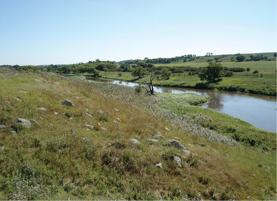
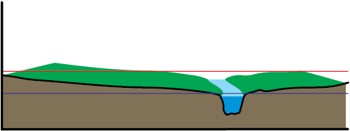
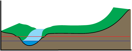
A riparian complex is the ecosystem associated with a stream, consisting of multiple surfaces, each supporting a unique plant community (Figure 1). A riparian complex ecological site is a unit of land with a unique set of biotic and abiotic factors that is capable of producing a distinct riparian complex and plant communities. While upland ecological sites in North Dakota are influenced primarily by soil properties, topography, climate, fire and grazing patterns, riparian complex ecological sites are largely influenced by stream hydrology.
The formation of surfaces and plant communities within a riparian complex is a direct result of geomorphological and hydrological processes. The primary factors that influence the riparian complex include valley type, stream type, stream gradient, channel substrates, fluvial surfaces, and vegetation patterns.
These factors vary across North Dakota due to differences in geology, soils, water, climate and topography. Areas that have similar geology, soils, water, climate and topography have been categorized by the U.S. Department of Agriculture’s Natural Resources Conservation Service (NRCS) as Major Land Resource Areas (MLRA).
Major Land Resource Areas
Major land resource areas are geographic regions characterized by soil patterns, climate, water resources and land uses. MLRA regions are important in statewide agricultural planning and have value in interstate, regional and national planning. The NRCS has defined 278 MLRAs, each defined by a descriptive geographic name and a number.
Eight MLRAs represent the majority of North Dakota (Figure 2). Each MLRA may support multiple riparian complex ecological sites due to this broad pattern of soils, vegetation and water resources. A stream or river may have multiple ecological sites if it crosses more than one MLRA.
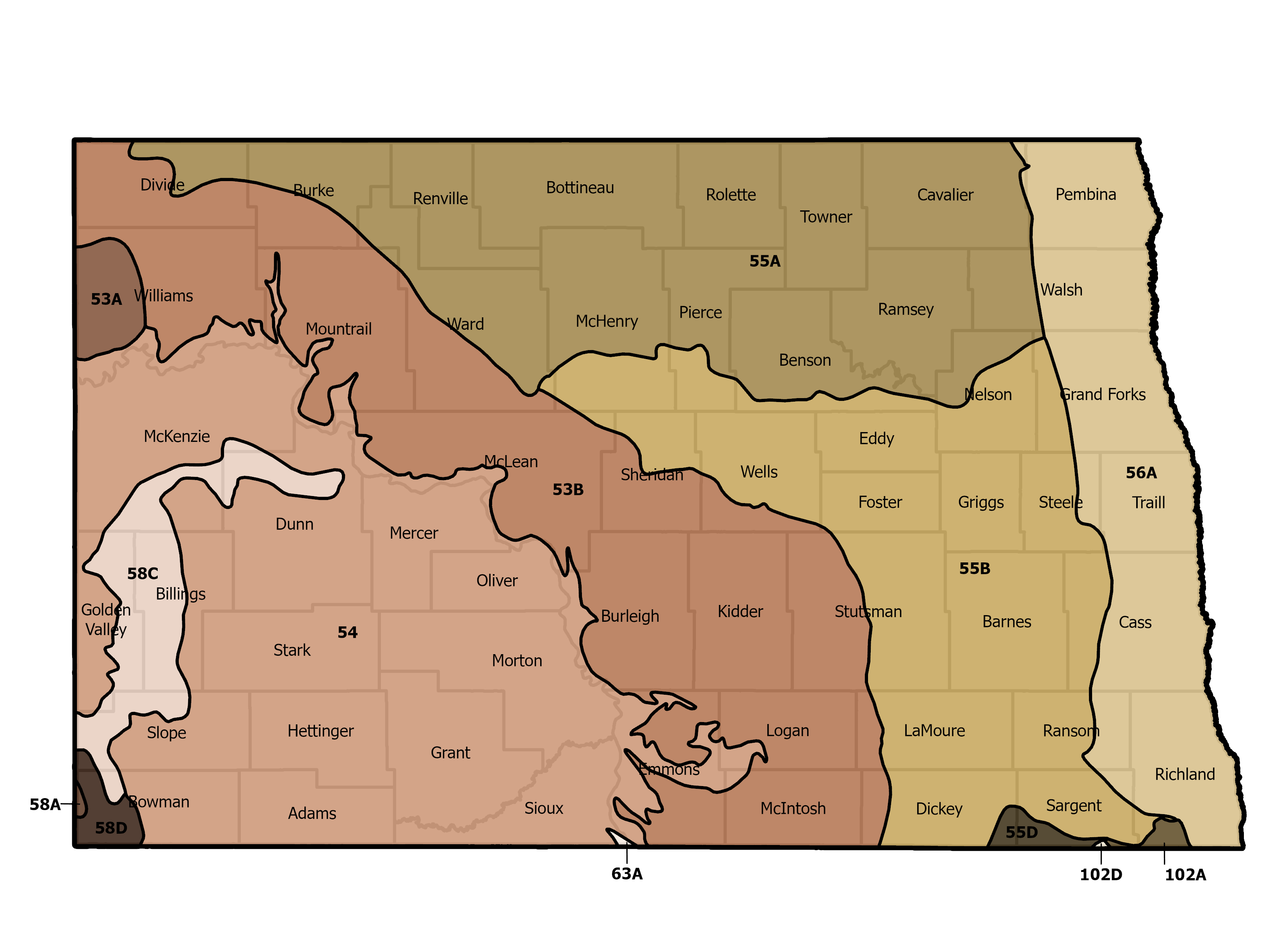
Long Description of Figure 2.
Map of North Dakota split into 13 different MLRA sections:
53A - this section is only part of western side of Williams county
53B - this section is north and east of the Missouri river and includes parts of Divide, Williams, Burke, Mountrail, Ward, McHenry, McLean, Sheridan, Wells, Burleigh, Kidder, Stutsman, Emmons, Logan, LaMoure, McIntosh and Dickey counties
54 - this section includes all of Stark, Mercer, Oliver, Morton, Grant, Hettinger and Adams counties and parts of McKenzie, Dunn, Golden Valley, Billings, Slope, Bowman, Sioux and Emmons counties
55A - this section includes all of Renville, Bottineau, Rollette, Towner and Ramsey counties and parts of Divide, Burke, Ward, McHenry, Pierce, Benson, Nelson, Grand Forks, Walsh and Cavalier
55B - this section includes all of Eddy, Foster, Griggs and Barnes counties and parts of Ward, McHenry, Pierce, Benson, Nelson, Grand Forks, Steele, Cass, McLean, Sheridan, Wells, Stutsman, LaMoure, Dickey, Ransom, Sargent and Richland counties
55D - this section is just small parts of southern Dickey and Sargent counties
56A - this section includes all of Trail and Pembina counties and parts of Cavalier, Walsh, Grand Forks, Steele, Cass, Ransom, Richland and Sargent counties
58A - this is a very small section in the west side of Bowman county
58C - this section is a winding and thinner section that goes through Dunn, McKenzie, Golden Valley, Billings, Slope and Bowman counties
58D - this section is small and is in the west side of Bowman and Slope counties
63A - this is a very small section of south east Sioux county
102A - this is a small section of south Sargent and Richland counties
102D - this is a very small section in southern Sargent county
Riparian Site Dynamics
Riparian ecosystems are highly dynamic. As a result of the fluvial activity in these ecological sites, the plant communities shift in response to the influences of erosion, deposition and water table on a fluvial surface.
Fluvial surfaces are the flood plains and terraces associated with a stream. Stream stability, which is linked to geomorphology, changes in response to shifts in climate, vegetation, or management.
Prior to European settlement, the primary disturbances impacting the stream channel, fluvial surfaces and riparian vegetation communities were hydrology, climate, fire, beaver activity and grazing by free-roaming herbivores. Historically, beaver populations were widespread and their activities had a large influence on riparian systems. The decline in beaver populations degraded streams and altered vegetation in riparian areas. Additionally, prolonged periods of drought and heavy grazing by herbivores can result in the loss of bank-stabilizing riparian vegetation. When followed by a flood event, this loss of vegetation often resulted in entrenchment of the stream channel and a change in stream type. Entrenchment reduces the size of the floodplain and lowers the position of the water table within the watershed.
Ecological site descriptions (ESD) provide a consistent framework for classifying and describing range and forest land soils and vegetation. Land is organized into categories based on shared capabilities and responses to management activities or disturbances. Each land site’s ecological dynamics are presented through a state-and-transition model (STM). Riparian complex ESDs describe the stream types, fluvial surfaces, plant communities and the site’s responses to disturbances. Figure 3 depicts a riparian complex STM for a perennial stream in MLRA 54, located in the southwest region of North Dakota.
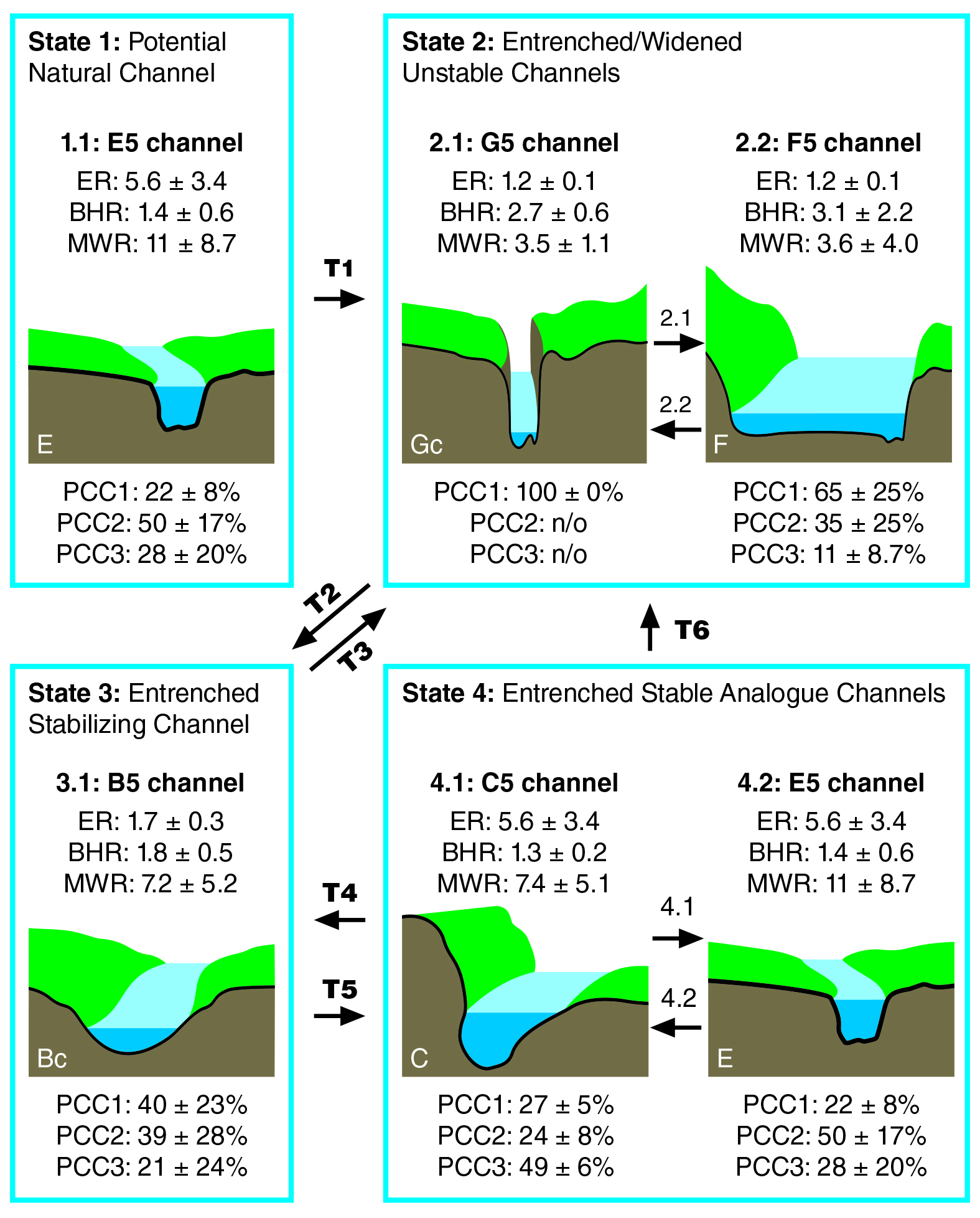
The STM depicts the current understanding of the ecological dynamics of the site. The STM, along with the ecological dynamics narratives, identifies and describes the different stream states, phases, thresholds, transitional pathways and drivers that may occur on a site. The STM describes the fluvial surfaces and plant community components and their relationship to the stream type in each state and phase. Understanding these dynamics helps land managers and owners predict how a riparian complex will respond to changes in management and various disturbance regimes such as drought, overgrazing, fire and grazing exclusion.
The stream type(s) in State 1 are referred to as the reference state or the potential natural channel(s). The reference state represents the stream channel and plant community components that would have occupied the site under the historic disturbance regime. This stream type is suited to transport the energy, water, and sediments supplied by the watershed, and promote the plant community components that provide stability to the system.
The potential natural channels, fluvial features and plant community components of the reference state are described based upon data collected from sites determined to be representative of historic conditions. Additional information is gathered from historical documents and other sources that describe the stream, streamflow and plant community components prior to settlement, when the natural disturbance regime would have occurred.
Since settlement, these sites have been subjected to numerous disturbances, such as changes in land use, removal of beaver, unmanaged grazing, or the removal of grazing within watersheds and floodplains. These changes have altered riparian plant communities, leaving streams vulnerable to entrenchment and altering the stream and riparian plant communities.
Additionally, non-native species such as Kentucky bluegrass, smooth bromegrass, reed canary grass, saltcedar, buckthorn and Russian olive have invaded sites and negatively impacted stream stability. Many stream systems have been subjected to direct hydrologic alterations from the development of infrastructure, livestock grazing, crop and forage production, and energy development. Stream reaches have been modified by channel straightening, agricultural drainage, bridge design, concrete crossings and dam construction.
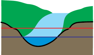
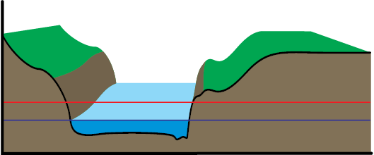
Disturbances to potential natural channels can result in stream entrenchment and floodplain abandonment. When this occurs, a threshold has been crossed to State 2, which consists of the unstable channels. These unstable channels are highly erosive and have no floodplain.
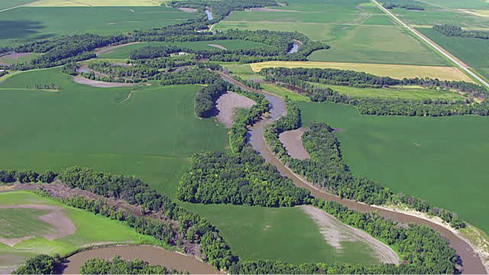
Once entrenchment has occurred, recovering the potential natural channel is nearly impossible without a major investment of time and money for restoration. The stream may stabilize within the new valley formed by entrenchment, forming a smaller, restricted floodplain.
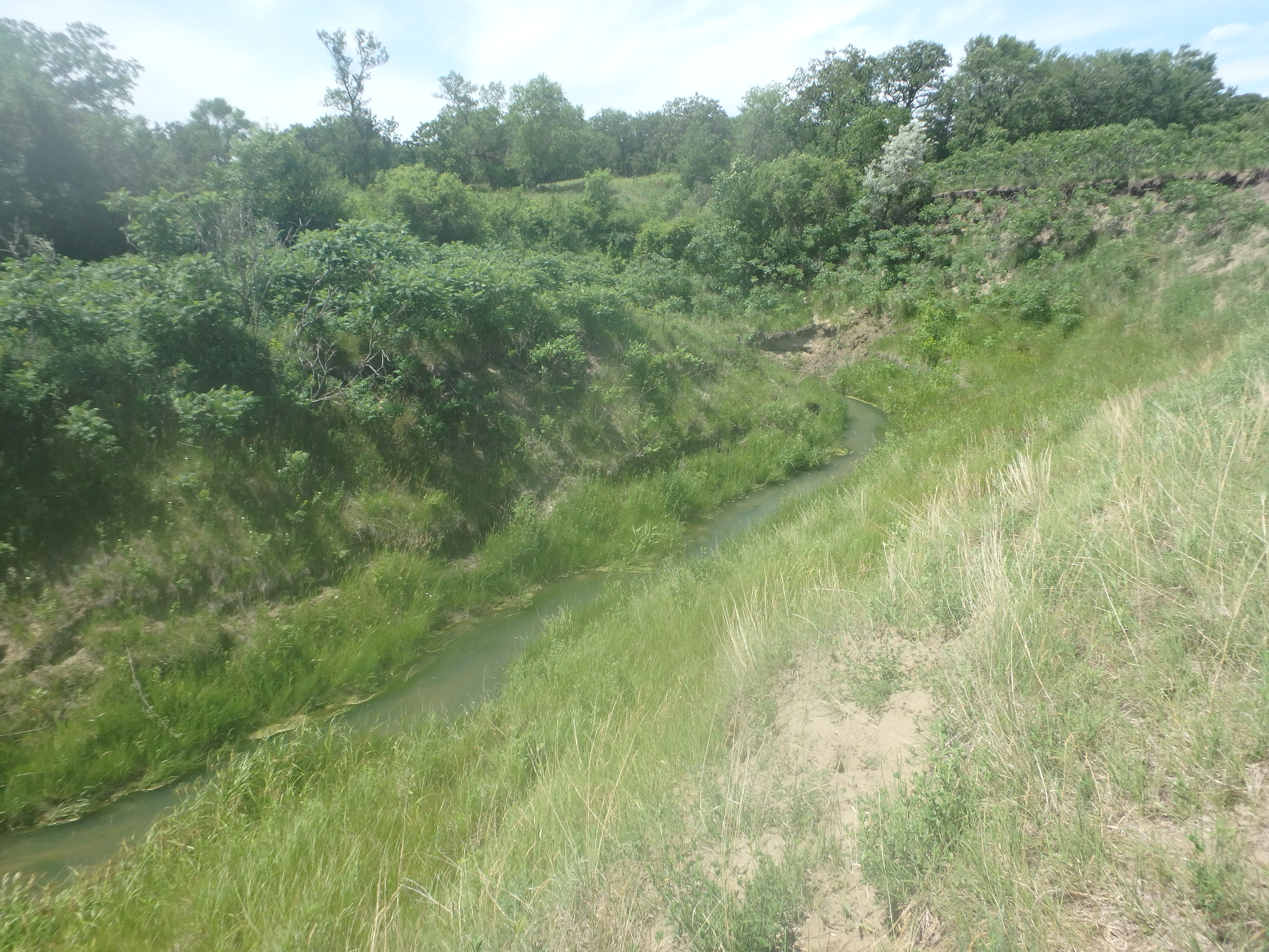
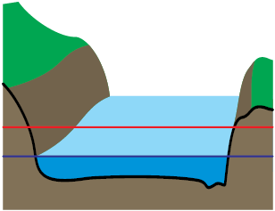
As the stream starts to stabilize and develop a deeper channel and new floodplain within the restricted floodplain, it crosses a threshold into State 3, the stabilizing state. This state occurs when the channel is in a state of building resistance and resilience. Management of stabilizing channels should include practices that promote floodplain development through the establishment of riparian plant communities.
As the stream continues to stabilize and the floodplain expands, it crosses a threshold into State 4, the stable analogue state, which consists of stable channels with restricted floodplains and plant community components due to past entrenchment. If these streams are not managed properly, they will transition back to State 2, where they become further entrenched.
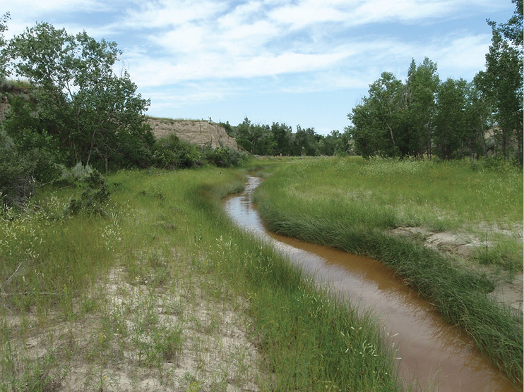
Stabilizing stream channel within a valley formed by entrenchment in North Dakota.
Streamflow


Valley Type
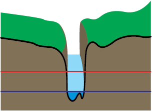
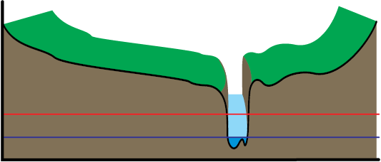
Alluvial Valley Type
The alluvial valley is described as a broad U-shaped structure with a gentle down-valley relief that has a well-developed flood plain and numerous glacial and alluvial terraces. Active alluvial terraces support riparian vegetation, whereas abandoned terraces are no longer connected to the stream or water table and are inhabited by upland plants.

Lacustrine Valley Type
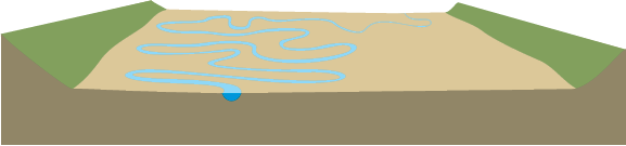
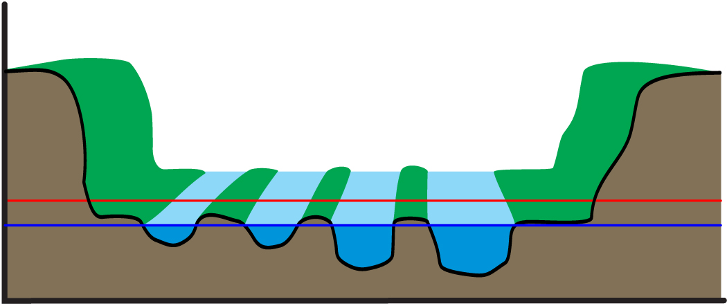
The lacustrine valley forms in old lake beds and is described as a very wide valley with gentle slopes. The lacustrine material that forms this valley can be from recent lakes or glacial lakes, such as Lake Agassiz.
The streams in this valley tend to have expansive floodplains that are frequently flooded and have many wetlands and oxbows. Many streams in the Red River Valley of eastern North Dakota belong to this valley type. The lacustrine valley type is able to support stream types B, C, D, E, F and G (See Figure 5).
Stream Type
Stream type is based primarily on the shape of the stream channel and sinuosity. Stream types can be defined further based on the slope of the channel and channel bed material. Rosgen (1985; 1994) developed a stream classification system based on these major variables that has been adapted by the Natural Resources Conservation Service and the U.S. Forest Service for the assessment of riparian complex ecological sites. Rosgen’s stream classification system allows natural resource managers to predict a stream’s behavior and compare data from one reach with that from similar reaches by grouping similar streams.
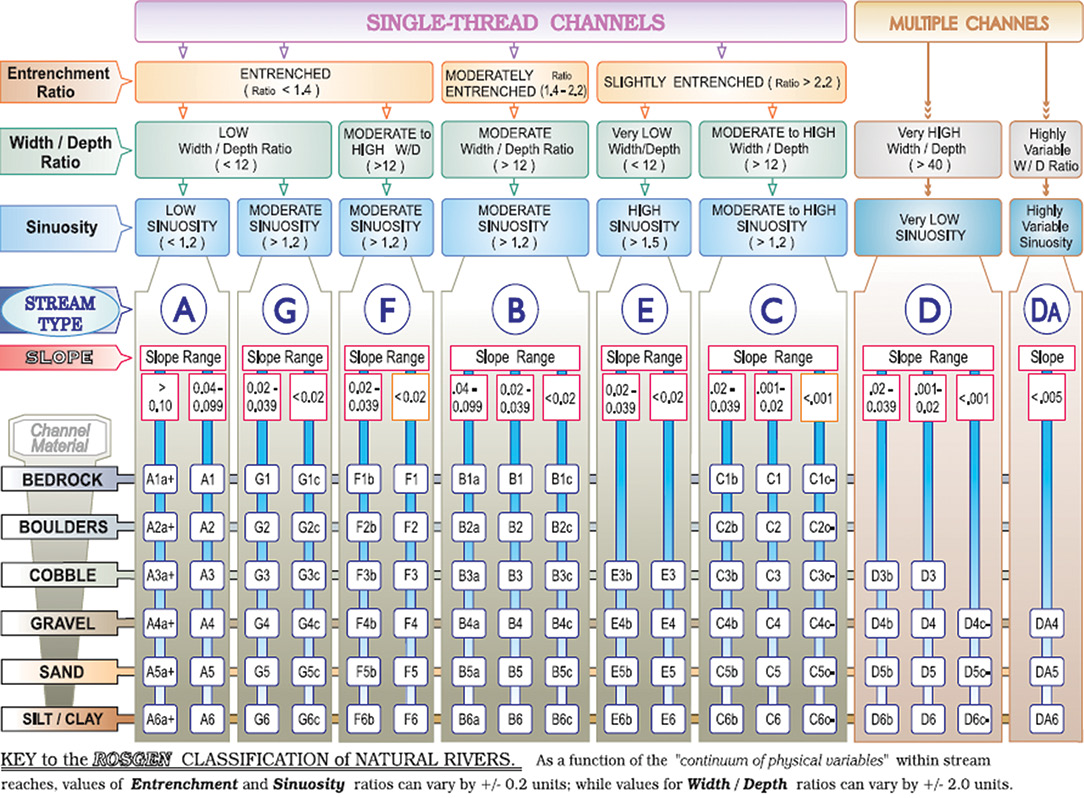
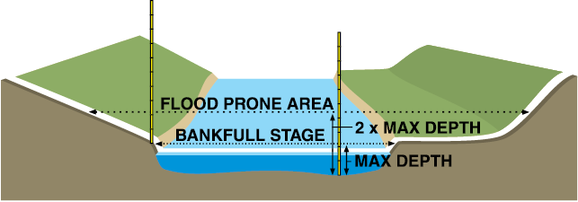
The specific measurements required to determine stream type are entrenchment ratio, width/depth ratio, and sinuosity. These measurements must be taken at a riffle within the reach being assessed. Riffles are located at the tail of a pool and are the shallowest portions of the stream.
To ensure measurements are accurate, identifying the bankfull elevation of the stream correctly is important. Bankfull elevation is the point where the stream leaves the channel and enters its floodplain.
Common indicators used to identify the bankfull elevation are the floodplain surface, vegetation line and top of bars. Bars are features formed when the stream deposits material. The bankfull flow is the channel-forming flow and occurs, on average, every 1.5 years.
Stream Profile


Width to Depth Ratio
The width-to-depth ratio is a measure of the stream’s ability to transport water and sediment. When a stream has a high width-to-depth ratio, it cannot transport sediment, and deposition occurs.
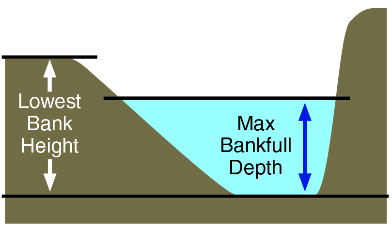
Width to depth ratio = bankfull width ÷ average bankfull depth
Example:
Bankfull width = 11.3 feet
Flood prone width = 38.42 feet
Mean depth = 2.8 feet
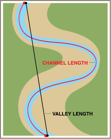
Channel length = 4,775 feet
Valley length = 2,999 feet
Entrenchment ratio = 38.42 ÷ 11.3
Entrenchment ratio = 3.4
Width to depth ratio = 11.3 ÷ 2.8
Width to depth ratio = 4.03
Sinuosity = 4,775 ÷ 2,999
Sinuosity = 1.6
Channel Bed Material
Channel bed material is denoted by a number one through six following the stream type. In North Dakota, the channel material of most streams is silts/clays (denoted by a 6) or sands (denoted by a 5). For example, an E channel with silt/clay as the channel material is an E6 stream.
Bank Height Ratio
While not part of the Rosgen’s stream classification system, bank height ratio (BHR) is another metric used to assess a stream’s ability to access its floodplain. Bank height ratio responds quickly to disturbance and can be an indicator that a stream is at-risk of transitioning to an unstable state. Bank height ratio is broken into stability groups where: stable is ≤ 1, moderately unstable is 1.1 – 1.3, unstable is 1.3 – 1.5, or highly unstable > 1.5.
E Streams
The E stream type is the most stable stream type and the potential natural channel for many streams in North Dakota. E channels are slightly entrenched (entrenchment ratio > 2.2), have a narrow and deep channel (width/depth ratio <12), and moderate to high sinuosity (> 1.5).
These streams typically have a large floodplain unless floodplain development is restricted by the valley. This happens when an E stream develops in a former F stream type or other confined valleys. An E stream is able to access the floodplain easily during bankfull flood events.
The water table associated with this stream type is elevated, supporting the expansion of highly productive riparian plant communities. A healthy riparian plant community is required to maintain a stable E stream.
Disturbances that alter streambank vegetation that result in the replacement of deep-rooted riparian plant species by shallow-rooted upland species, can destabilize streambanks and increase sediment loads. These changes make the stream at risk of transitioning to a less stable or unstable stream type.


C Streams
The C stream type is characterized by active lateral movement, with material being removed from outer bends (cut banks) and deposited on inner bends (point bars). C channels are slightly entrenched (entrenchment ratio > 2.2), have a moderate to high width-to-depth ratio (>12) and moderate to high sinuosity (> 1.2).
The C channel is the potential natural channel for some streams in North Dakota that have sand as the dominant channel material. Due to the active lateral movement of C streams, they have a high sediment supply unless streambanks are well-vegetated. These streams typically have a well-defined floodplain with numerous fluvial features (terraces) as a result of deposition during flood events. Each of these features supports a different plant community, the composition of which is dictated by the depth to the water table.
A healthy riparian plant community is required to maintain a stable C stream or facilitate the transition to a more stable E channel (if that is the potential natural channel for the site). A healthy greenline plant community traps sediments, aiding in floodplain development. Disturbances that alter streambank vegetation, such as the replacement of deep-rooted riparian plant species by shallow-rooted upland species, can destabilize streambanks and alter sediment loads. These changes make the stream at risk of transitioning to a less stable or unstable stream type.


B Streams
The B stream type is characterized as having a parabolic shape and is the most widely documented channel in North Dakota to date. This channel is categorized as stabilizing in the riparian systems of the Great Plains, acting as a transitional state between unstable and stable channels. B channels are moderately entrenched (entrenchment ratio of 1.4-to-2.2), with a moderate width-to-depth ratio (> 12) and moderate to high sinuosity (> 1.2).
In North Dakota, the B channel has a shallow slope and channel bed materials consisting of silt and clay (denoted by a 6) or sand (denoted by a 5). This stream is indicative of past disturbance because it is a stabilizing channel that is associated with the early stages of floodplain development. These streams typically have a very narrow floodplain consisting of early successional riparian species. Due to its stabilizing nature, this stream is considered at-risk of destabilization. Thus, management has a significant influence on the trajectory of B channels, promoting stability or causing it to return to an unstable state.


F Streams
The F stream type is an unstable channel that is shaped like a trough with a wide, flat bottom and vertical sides. F channels are entrenched (entrenchment ratio <1.4) and do not have an active floodplain. These streams are wide and shallow (width-to-depth ratio > 12) and relatively straight (sinuosity is >1.2) when compared with the potential natural channels.
In North Dakota, the channel material of this stream is silt and clay (denoted by a 6) or sands (denoted by a 5). The stream is unable to access the floodplain, which causes the streambanks to experience increased force during flood events, leading to an increase in erosion, sediment loads and channel widening. However, this process is required to facilitate floodplain development and the transition to a stable B, C, or E channel.


G Streams
The G stream type is highly unstable with a gully like channel that is narrow and very deep (width-to-depth ratio <12). G channels are entrenched (entrenchment ratio <1.4), having lost connection to the floodplain due to down-cutting. Down-cutting is often a response to changes in grade and increased erosion and/or sediment loads.
These streams are relatively straight (sinuosity is >1.2) when compared with the potential natural channels, decreasing sinuosity, and increasing the speed and force of floodwaters.
Because the stream is unable to access the floodplain, the increased force leads to increased erosion of the streambank, sediment loads, and channel down-cutting and widening. The high instability of this channel in North Dakota is increased by the erodibility of silts/clays and sands channel material. As a result, these streams often quickly transition to F or B streams.

D Streams
The D stream type is characterized as having multiple channels and commonly called a braided stream. D channels are common on streams with high sediment loads such as the Upper Missouri River and Platte River. However, D streams are typically considered an unstable channel type and result from increased erosion within a watershed. D streams have a very high WDR (>40) and very low sinuosity.

Riparian Plant Community Components
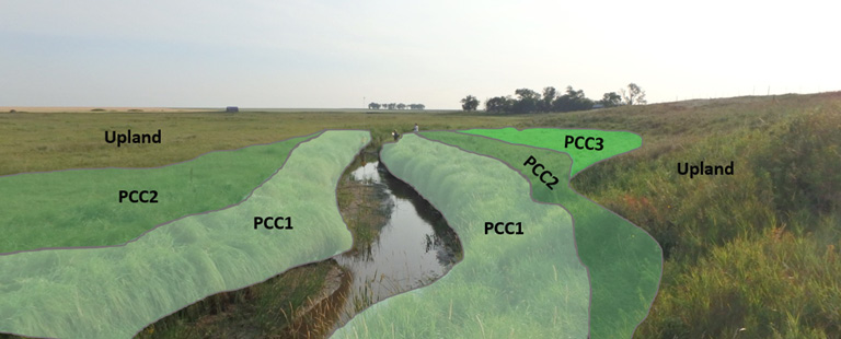
Riparian complex ecological sites consist of numerous plant communities called plant community components (PCC). Each PCC is associated with a different fluvial surface and supports a distinct arrangement of plant functional groups and species. PCCs are assigned a number based on their location relative to the stream, with PCC1 occurring nearest to the stream. Riparian complex sites across North Dakota typically support two to five PCCs, though three is the most common. The PCCs associated with a site and the percentage of each are a function of the stream type. PCCs dominated by riparian species are associated with stream types B, C and E, and are often absent at sites with stream type G or F (see STM in Figure 3).
The species and functional group composition of PCCs varies depending on MLRA, valley type, flooding frequency, depth to water table, and dominant channel material. Reference Table 1 to determine what types of plants are expected to occur in different PCCs in relation to streamflow based on their wetland indicator status. Wetland indicator status groups plants by the frequency in which they are present in wetlands. The groups are obligate (>99%), facultative wetland (67-99%), facultative (34-66%), facultative upland (1-33%), and upland (<1%).
Table 1. Expected PCC in relation to streamflow.
| Plant Community Component (PCC) | Perennial | Intermittent |
| PCC1 | Obligate wetland sedges | Obligate and facultative wetland grasses and sedges |
| PCC2 | Obligate and facultative wetland grasses and sedges | Facultative and facultative upland grasses |
| PCC3 | Facultative and facultative upland grasses | Facultative and facultative upland grasses |
Riparian plant communities and channel geomorphology are reciprocally linked. A change in stream type can influence PCCs, and a change in PCC composition or size can influence stream type. This is especially true of changes within the PCC1 and greenline plant community, which is located at the water’s edge at the bankfull elevation or slightly higher. The presence of riparian species in the greenline community is maintained by seasonal flows and the local water table. When stream entrenchment results in a loss of hydrologic connectivity with the stream’s water table, that floodplain feature and PCC are no longer part of the riparian complex and become a terrace ecological site, which supports upland plant species.
Considerable scouring occurs in the floodplain closest to the stream on an annual basis as part of seasonal flooding, so the plants in this community are adapted to this frequent disturbance and function to protect and stabilize banks. Riparian plants have many growing points, enabling them to produce many stems and deep roots that help stabilize stream banks.
The greenline plant community (PCC1) is subject to damage by natural forces that include extreme flooding and drought, and anthropogenic actions, including channel modification (bridges, crossings, straightening), improper grazing management, and crop production. Extreme or long-term drought can cause an increase in the presence of upland plants with shallower roots within the riparian area, which can reduce stability over time. Overgrazing tends to facilitate the invasion of Kentucky bluegrass, a shallow-rooted upland species; however, the absence of grazing within the northern Great Plains makes sites susceptible to invasion by smooth brome, another shallow-rooted upland species.
Replacement of the native plant community by shallow-rooted upland species that are not capable of protecting and stabilizing banks results in the formation of tensile cracks, bank sloughing, and accelerated lateral channel movement (unstable state). In the unstable channel phases, PCC1 is restricted with high amounts of bare ground and often comprised of early successional plants. The stream is subject to extreme bank erosion.

