Origination of Produced Water (Brine) in the Williston Basin
(WQ2083 Feb. 2023)This publication details the geologic history of the Williston Basin and the source of produced water (brine) in the basin. It details the process for handling produced water, as a by-product of oil and gas production.
Contact your county NDSU Extension office to request a printed copy.
NDSU staff can order copies online (login required).
Williston Basin Context
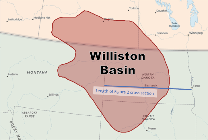
The Williston Basin is a sedimentary basin found in southern Saskatchewan, southeastern Manitoba, eastern Montana, northwestern South Dakota, and North Dakota. A large portion of North Dakota is underlain by the Williston Basin. The Williston Basin is one of the most complete sequence of sediments found worldwide spanning the past 500 million years. The geographical extent of this 110,000-square-mile basin is shown in Figure 1.
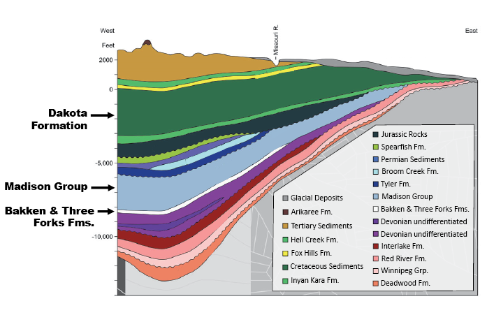
The oldest sedimentary unit in the Williston Basin (the Deadwood Formation) was deposited in the early Cambrian period over 500 million years ago with younger sediments being almost continuously deposited up until the Quaternary period (about 2.5 million years ago). Exceptions to this include four brief moments in time not recorded with the rest of the geologic history represented within the Williston Basin. The Williston Basin is made up of a wide variety of rocks that were deposited in terrestrial, fluvial (river) and, most abundantly, marine settings. The depth and relative thicknesses of rocks that make up the Williston Basin in North Dakota are shown in Figure 2.
History of Oil and Gas Exploration
Some of the most notable rock units within the Williston Basin are the Bakken and Three Forks Formations, as they currently hold most of the oil and natural gas that North Dakota produces today. Oil was first discovered in North Dakota in 1951, and historically the Madison Group (consisting of the Mission Canyon and Charles Formations) produced most of the oil and natural gas during the mid to late 1900s when conventional production techniques dominated this area (Figure 3). In the early 2000s, oil production from the Bakken and Three Forks Formations began to exceed production from the Madison Group due to advances in unconventional drilling (Figure 3).
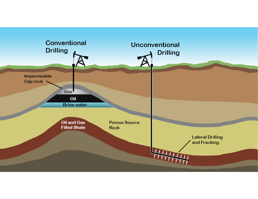
Unconventional drilling involves drilling down vertically to a kickoff point where drilling then continues horizontally through rock units. Once drilling is complete, hydraulic fracturing, also known as “fracking,” is used to further increase production in rocks with poorly connected pore systems. As proppant-bearing (containing sand and or man-made ceramic beads) frac fluid is pumped in, pressures increase, causing rocks to fracture. Frac fluid rich in proppant then enters the induced fracks, which are then held open by sand or ceramic material.
Conventional drilling, on the other hand, usually only involves drilling down vertically into large oil and natural gas reservoirs. There is often no need for fracking when conventional methods are used; however, fracking has at times been applied on vertical wells. Although unconventional drilling is more labor intensive and time consuming, its use allows access to immense amounts of untapped reserves of oil and natural gas within the Bakken and Three Forks Formations that far surpass reserves found within the Madison Group and other conventional reservoirs in the Williston Basin.
Geology and Formation of Oil and Gas Holding Rocks
The Bakken Formation is an offshore marine deposit composed of both shale and siltstone and ranges in thickness from 75 to 150 feet. The Three Forks Formation directly underlies the Bakken Formation and is a nearshore marine deposit composed of shale, siltstone and dolomite. The Three Forks Formation reaches 250 feet thick near west-central North Dakota.
The Bakken Formation was deposited during both the late Devonian and early Mississippian Periods (about 360 million years ago), and the Three Forks Formation was deposited during the late Devonian Period (385-359 million years ago). Despite being two separate rock formations, the Bakken and Three Forks are often thought of as being one unit. The Bakken and Three Forks Formations range from 8,500 to 10,000 feet in depth below ground surface in the western part of North Dakota.
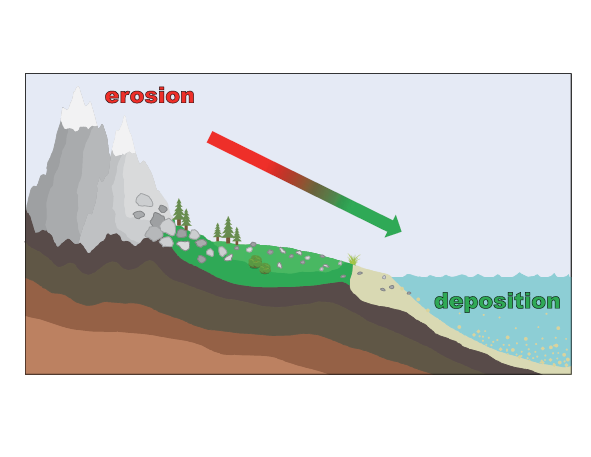
Millions of years and a variety of geologic processes are required to transform marine sands and silts into rocks that contain oil, natural gas and the by-product brine water. Oil and natural gas originate from aqueous derived plant and animal debris, sometimes referred to as organic material, that was altered by high temperatures and pressures in anaerobic (without oxygen) conditions. The amount of organic material that was deposited over 350 million years ago was dependent on rates of deposition and sedimentation. Many continental sediments erode from high points like hills or mountain tops and are deposited in depressional areas like basins, lakes or oceans (Figure 4). This is why there is a continuous accumulation of sediments in marine basins.
Conditions leading to the formation of oil and natural gas need to be ideal. This means that there needs to be favorable climate conditions to support appropriate plant and animal communities necessary for forming petroleum fuels. Low energy depositional environments are necessary to bury organic material and promote anaerobic degradation before organic material can be scavenged upon. Beach environments, for example, are less than ideal for organic matter accumulation because as waves crash upon the shore, water is aerated and the contact between bacteria and organic material is accelerated leading to decomposition rather than accumulation.
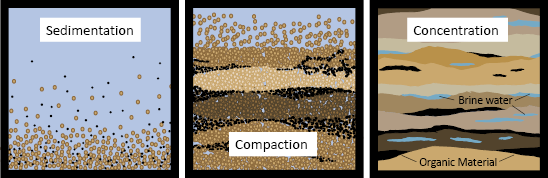
As sedimentation occurred in marine environments, organic material was buried by sediments that were loosely compacted and, during a majority of the Paleozoic era (540–248 million years ago) in North Dakota, saturated with sea water. As deposition and sedimentation continued, organic material and salts (primarily NaCl) from sea water were concentrated as water was squeezed out from between pore spaces due to increased pressures building above (Figure 5).
Formation and Occurrence of Oil, Gas and Brine
Pressures and temperatures build as sedimentation continues and at depths of about 0.6-1.2 miles (1-2 km) below ground surface and at temperatures of about 120 degrees Fahrenheit, accumulated plant and animal debris is converted into a substance known as kerogen through a process called diagenesis. Kerogen is a waxy, insoluble, sedimentary organic material. The formation of kerogen from plant and animal material is the first step in altering organic material into fossil fuels (Figure 6).
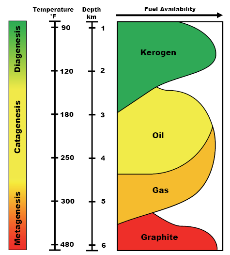
At depths reaching 1.8-3.0 miles (3-5 km) below ground surface and temperatures ranging from 180-250 degrees Fahrenheit (80-120 degrees Celsius), kerogen is converted into oil through a process called catagenesis, which is a type of thermal degradation. The formation of natural gas comes later only if temperatures continue to increase to between 250-300 degrees Fahrenheit (120-150 degrees Celsius). If temperatures continue to rise to near 400 degrees Fahrenheit (200 degrees Celsius), however, oil and natural gas will go through a process called metagenesis. Metagenesis will mineralize oil and gas, turning them into graphite, as they combust under high temperatures and thus will no longer be a fossil fuel. Although increasing temperatures and pressures drive the transformation of organic material to oil and gas, time is an additional factor not shown in Figure 6. High temperatures and pressures that continue for prolonged periods of time are much more effective at generating oil and gas than short surges of these conditions.
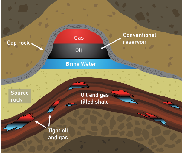
Oil and natural gas tend to move through connected pore spaces in rock and accumulate in areas where porosity in rocks is low and permeability is no longer feasible. Concentrated ocean water, also known as brine, brine water or produced water, also travels through rocks and accumulates with oil and natural gas. In these pockets where there is stratification due to density differences, oil floats on brine and gas floats on oil (Figure 7).
Production and Separation of Oil, Gas and Brine
This heterogeneity (distinct stratification) of brine, oil and gas is disrupted by drilling and fracking processes. Disturbances caused by high intensity fracking and pumping cause oil, gas and brine to be brought to the surface as an emulsion (a homogenous mixture) (Figure 8). The amount of brine produced in the Williston Basin alongside oil and gas varies through time. Newer wells typically produce about a 2:1 to 4:1 ratio of oil to brine, whereas older wells produce ratios ranging from 1:2 to 1:100 of oil to brine.
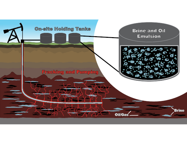
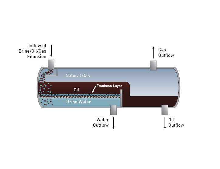
There are onsite and offsite processes that aim to separate brine from oil and gas because of the negative impacts that brine can have on machinery, refinery equipment and the environment. Once at the surface, gas readily separates from oil and brine through density differences in onsite tanks, leaving oil and brine behind. Below, Figure 9 shows a simplified version of how brine, oil and gas are separated from each other. In these same tanks, some brine separates from oil without assistance. Additional heat, pressure, separation agents and mixing elements are often necessary to remove brine from oil before further, offsite refinery processes can take place.
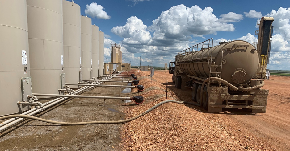
Potential Risks of Disposal and Transportation
Once brine is separated from oil and gas, it then needs to be safely disposed. Disposal is typically done through deep well injection into the Dakota Formation (Figure 2), which is a Cretaceous-age rock unit (108-94 million years ago) nearly 5,000 feet below ground surface in western North Dakota. Pipelines are the most common mode of transporting brine to injection site (Figure 10a). Trucks are also used to transport brine because they are versatile for shorter distances (Figure 10b).
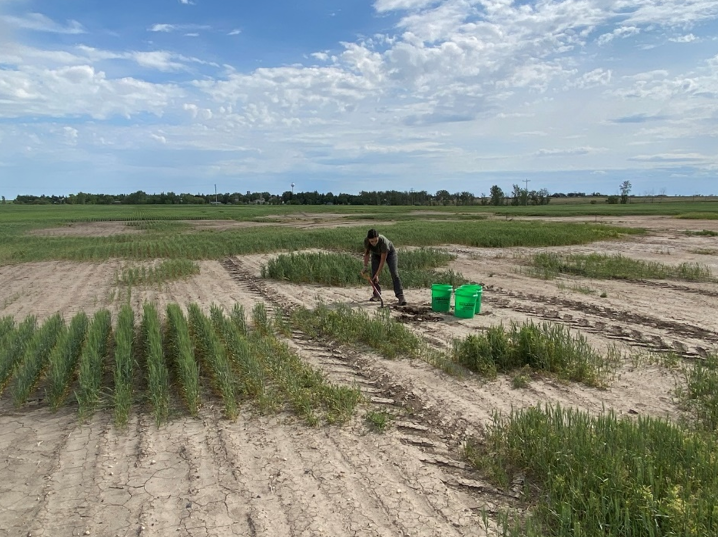
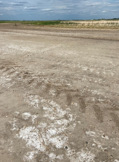
Most brine spills occur during the transportation of brine to an injection well site. In many cases, these spills can go initially undetected, especially when pipelines fail underground. Brine spills can range from a few hundred gallons to upwards of a few million gallons. Brine impacted areas often exhibit sparse vegetation (Figure 11a) and an accumulation of salts at the surface (Figure 11b). Brine spills can often be worse than oil spills because oil will naturally degrade over time, whereas brine is inorganic and does not degrade. For more information on the environmental impacts of brine refer to NDSU Extension publication R1850, Environmental Impacts of Brine (Produced Water).