A Mobile Web-mapping Application for Real-time Monitoring of Palmer Amaranth in North Dakota
(Research Report, Carrington REC, December 2020)Introduction: The increase and continued expansion of noxious weeds in North Dakota represents a potential danger to the region’s agricultural markets. North Dakota state law (NDCC § 4.1-47-02) mandates that weeds identified or listed as noxious and troublesome must be controlled. Currently, North Dakota offers regular updates and recommendations for chemical control for a variety of troublesome and noxious weeds. In addition, information pertaining to biological control may be found by contacting the North Dakota Department of Agriculture or local staff of the United State Department of Agriculture - Animal and Plant Health Inspection Service. The recent expansion of palmer amaranth (Amaranthus palmeri) throughout the state is of concern given its propensity to develop herbicide resistance, prolific seed production, and rapid rate of growth. Moreover, palmer amaranth can contribute to decreased yields, and gained its notoriety as it impacted the cotton industry in the southern United States. In North Dakota, palmer amaranth is a threat to the state’s primary crops including soybean, sugar beet, and corn. Purdue University estimates that palmer amaranth has the potential to reduce soybean yields by up to 79%.
In addition to traditional reporting methods, it is important to monitor the presence and proliferation of noxious weeds in a spatial context. Whereas eradication efforts are often conducted when noxious weeds such as palmer amaranth are identified, the mapping of locations will aid in further understanding the spread of such weeds, as well as the environmental factors that drive such spread. To this end, Extension staff at the Carrington Research Extension Center have started development of a mobile-based tool that will facilitate the acquisition of spatial data as it pertains to palmer amaranth and other noxious weeds within the state. Current technology provides a robust framework within which to develop this mobile application. Utilizing both the Android and IOS Software Development Kits (SDK), as well as Geographic Information System (GIS) technology, this mobile application can be rapidly deployed and utilized via a traditional “smartphone” environment. Furthermore, the application will be “scalable” meaning that the application will be updated as new threats emerge. This relatively new technology offers an efficient and lightweight method of monitoring the presence and spread of noxious weeds within the state, and will contribute to ongoing mitigation efforts as required under state law. The current beta version allows the user to document one of four different noxious weeds, and stores the GPS location, a photograph, the county within which it is located, and the relative prevalence. Further attributes will be defined based on discussions with Extension staff and weed specialists.
Application Framework: The spatial databases will be developed utilizing the ArcGIS Geodatabase model. This particular spatial model provides a mechanism to create a menu-driven form in the mobile application, while simultaneously storing the spatial (location-based) information related to the distribution of noxious weeds within the state.
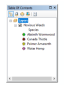
Attribute information is stored in the “Noxious_Weeds” feature class (Figure 1) that is contained within the “Noxious_Weeds” Geodatabase. This feature class will be populated by the mobile application, and subsequently consumed by the online web map, and associated online dashboard. The web map and dashboard will utilize either the North Dakota State University ArcGIS Online (AGOL) organizational account or North Dakota State University’s ArcGIS Enterprise Server licensing and an associated PostGreSQL spatial database. The beta version of this application utilizes AGOL for ease of use and the rapid manner in which a “proof of concept” can be developed. Moreover, the feature class will be updated via the mobile application, which will be developed using the ArcGIS AppStudio Developer’s Edition and will run on both Android and IOS mobile devices. The Android and IOS devices will need to install ArcGIS AppStudio Player which will allow the application to run prior to deployment as a full executable software installation.
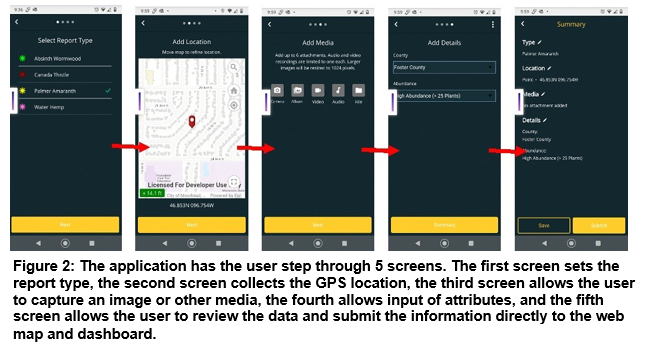
The mobile application itself allows the user to navigate several screens with ease, and integrates the internal GPS chip found in modern Android and IOS devices (Figure2). The final dashboard and web map allow for near real-time updating and monitoring of distribution across the state.
Summary: The relative ease with which the application can be downloaded and deployed will facilitate more reliable collection of data as it pertains to noxious weeds in the state. Moreover, data that are collected will integrate with the current state-wide efforts to monitor noxious weeds throughout the state. The architecture upon which the application is designed allows for a scalable solution that can evolve as the needs and focus change. It is expected to go directly to field evaluation this spring with Extension agents utilizing the application in instances where palmer amaranth or other noxious weeds are identified. Further development will occur upon consultation with state weed scientists to determine the appropriate attributes that should be collected.