Preparing for Severe Weather

The North Dakota State Climate Office has a few reminders for you to keep yourself safe when facing severe weather commonly seen across the Northern Plains.
Always take the possibility of severe weather into consideration when making plans at school, home, work, and when traveling. Pay close attention to weather forecasts and find where your closest storm shelter is in the days ahead.
Have a way to receive alerts! Weather radio, phone, TV, or social media are a few ways to stay weather aware.
Weather information
Severe Thunderstorms
The first step in planning for severe weather is ensuring that you understand the messaging. The National Weather Service issues Watches, Special Weather Statements, and Warnings:
- Special Weather Statements can be issued for a number of meteorological reasons, but in the summer it is commonly used to indicate an impactful storm that doesn’t meet the criteria necessary for a Warning. They are issued when when there are less hazardous conditions, but weather may still pose a potential threat to life and property.
- Watches vs. Warnings
- A Severe Thunderstorm Watch is typically issued hours before severe weather is forecast- conditions are favorable to develop a thunderstorm, well before it may occur. It can cover a broad area, and not all locations within the watch may see thunderstorms. Stay up to date on the forecast from the National Weather Service, local news, or radio.
- A Severe Thunderstorm Warning is issued when impactful severe weather is imminent in your area. Read the warning, understand the hazards, and take the necessary precautions to stay safe.
- 58+ mph wind gust
- Hail greater than one inch diameter (quarter size)
It is important to note that all Watches and Warnings are issued by the National Weather Service ONLY. Phone weather apps and broadcast media display and communicate messages issued by the NWS. Always get weather information from a trusted source!
Lightning
Lightning is the star of every thunderstorm!! Thunder is the first sign that you should start to take precautions to protect yourself and others if you are outdoors. Even if it is not raining, if you can hear thunder, lightning is close enough to strike you. Lightning can strike as far as 15 miles away from any rainfall. The best place you can be to avoid lightning is in a building or hard topped vehicle.
- Cease any and all outdoor activities
- If you are in or on open water, get to land and shelter as soon as possible. Water will conduct electricity and put you in danger.
- Avoid open fields, isolated fields, and tall objects
- Only resume outdoor activity 30 minutes after you last hear thunder
Hail
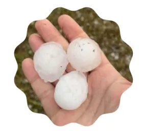
Thunderstorms can unpredictably drop hailstones from pea size to well over 2" in diameter. It is best to avoid being outdoors! If you are driving and encounter hail, pull over safely until it is clear.
Tornadoes
Though less commonly seen in North Dakota than elsewhere on the Plains or in the Midwest, since 2004 North Dakota averages 34 tornadoes per year! It’s important to take warnings seriously and know what to expect in a tornado warned thunderstorm.
- Sirens will sound according to your county or city, and you may receive an alert if enabled on your smartphone.
- Immediately seek shelter in the lowest level of the building in the most interior room, like a bathroom with a bathtub. Use any items to protect yourself, such as a helmet or pillow.
- Ideally, make a plan ahead of time with your household in case of a weather emergency.
- Funnel Clouds A funnel cloud is a spinning column of air descending from a storm. It is not a tornado until the condensation funnel has touched the ground, but rotation does warrant a Tornado Warning and sirens may sound.
- Tornado Once the funnel has contact with the ground it can immediately cause damage to its surroundings. Debris can be thrown at high speeds no matter the size of the tornado.
- Rain-Wrapped Tornadoes Oftentimes tornadoes become “rain-wrapped” — when the rain shaft of the thunderstorm reduces visibility of the tornado. This is very dangerous, as it is nearly impossible to see where the funnel is. Stay sheltered until safety is confirmed.
- Plan Ahead! Know beforehand where to seek shelter and what to do in an emergency. Locate tornado shelters in buildings you attend throughout the day. A tornado can occur at any time day or night.
- Phone Alerts When enabled, your phone will automatically be alerted of a tornado warning in the area. Stay up to date on changing weather conditions via phone, TV, or radio
Flash Flood
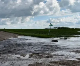
Flash flooding is common in North Dakota when a strong and persistent rainfall overwhelms or even damages local infrastructure. It is easier than it may seem for you or your vehicle to be swept away in flooded roadways. Excessive rainfall can strengthen currents in streams or creeks, making them dangerous for recreation. Urban areas are perceptible to flash flooding due to concrete and asphalt surfaces that do not allow rain to penetrate the soil.
It only takes around:
- 6 inches of fast moving water to sweep away an adult
- 12 inches to sweep away a vehicle
- 18-24 inches to sweep away a truck or SUV
Do not attempt to pass flooded roadways! Turn around, don’t drown!